My experience in designing ‘trawl corridors’

Unlike the Sea Change 2017 marine spatial plan that sought to phase out bottom impact fishing from the Hauraki Gulf Marine Park the governments response (Revitalising the Gulf 2021) was to create ‘trawl corridors’. Bottom trawlers do not have a public license to keep smashing the seafloor, a 2021 Horizon Research poll had 84% support for a banning the practice. I love the seafloor and volunteer for an organisation that restores damage done to it by bottom impact fishing. I’m completely opposed to trawling as a fishing method but I put my hand up to help limit its impact in the Gulf using a science based process by joining the Hauraki Gulf – Benthic Spatial Planning Advisory Group (HG-BSPAG).

This was my first experience in a collaborative decision making process run by the Government with industry representatives. I represented an environmental Non-Government Organisation (eNGO), there were three eNGO participants, everyone else was either from NIWA, central & local govt or the fishing industry. The process was chaired and controlled by Fisheries NZ. The other two eNGO participants were awesome and I learnt a lot from them.

I particularly liked the data first approach to marine spatial planning, Zonation is a great tool and I liked the way it starts by removing the human impacts then making an economic case for re-introducing them. Unfortunately some data that would have been useful was not quite complete.

Fisheries NZ controlled the outputs by defining what is in scope. Here is a list of requests that were disregarded:

  1. Ground truthing the modelling work (out of scope).
  2. Modelling the distribution of Unwanted Organisms (UOs) . We know from NIWA surveys that trawl nets catch UOs in the HGMP, transporting UOs is an offence under Section 52 of the Biosecurity Act 1993. By excluding UO’s from the study FNZ failed to protect native benthic habitats from UO’s which can be spread by bottom impact fishing (see appendix for more details).
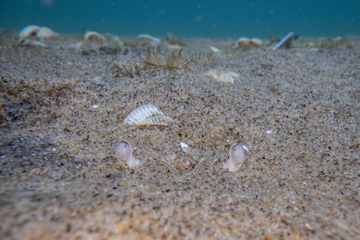
  3. Infauna (animals that live in the sediments) that are sensitive to bottom impact fishing were excluded from the modelling due to technicalities.
  4. Mobile species that contribute biogenic habitat like tipa / scallops (see appendix) and burrowing animals like ghost shrimp and crabs were excluded because they were mobile which did not suit their definition of biogenic habitat. This is ridiculous as the smallest grid size is 250m and previously mentioned adult animals are unlikely to move more than 10m.
  5. Important habitats for fish (like spawning and nursery areas) were not considered (out of scope).
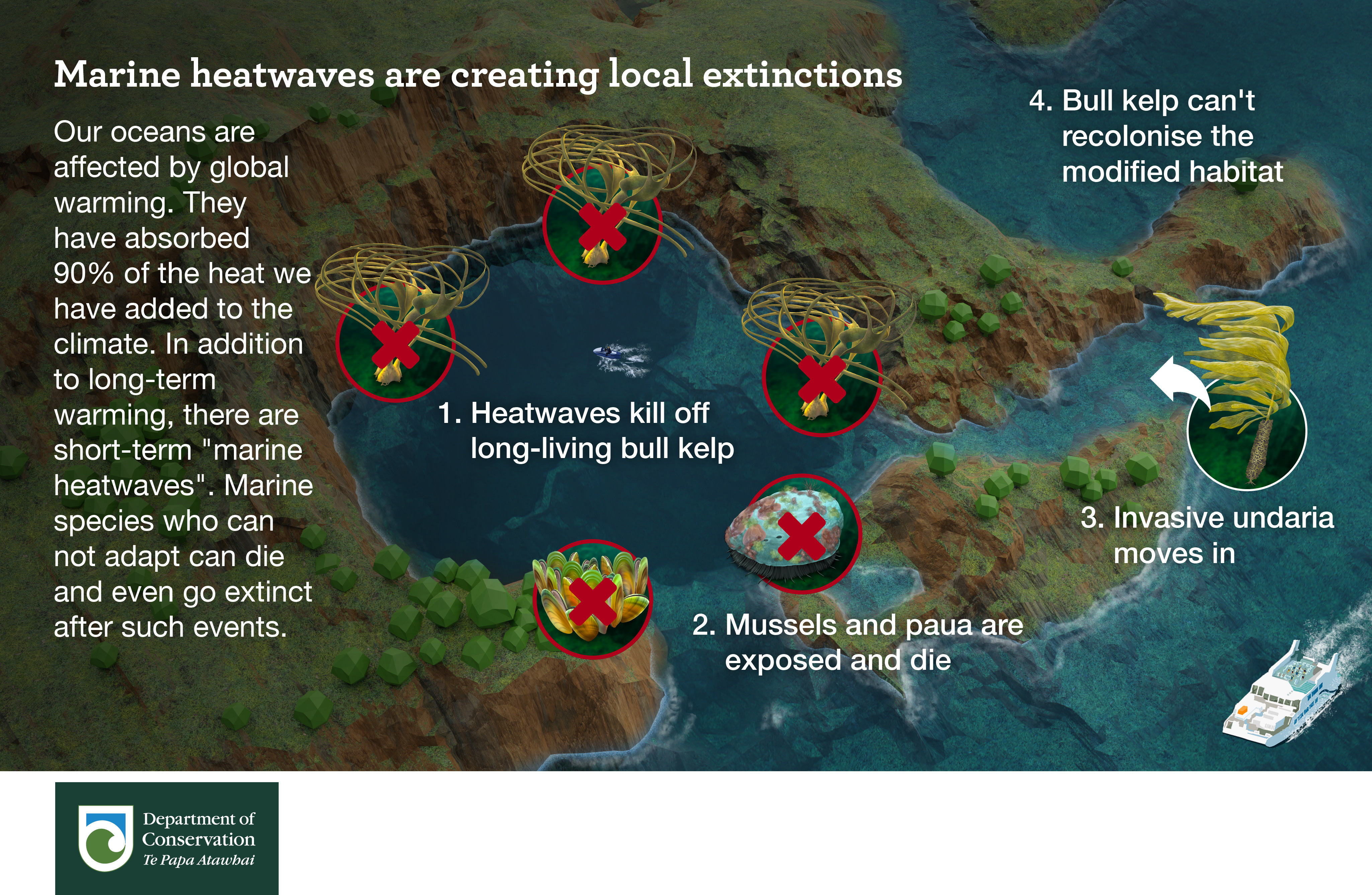
  6. The indirect effects of bottom impact fishing. Sediment plumes from bottom impact fishing choke and kill filter feeding animals and smother photosynthesising plants. These effects were not included but have been discussed at the end of the report.
  7. Climate change impacts (e.g. CO2 released from resuspending sediments and heart urchins moving deeper as water warms) also not included but have been discussed at the end of the report.
  8. Modelling the economic benefits of excluding bottom impact fishing to other fisheries that don’t impact the seafloor, this could have dramatically altered the findings (out of scope).
  9. Monitoring changes in the money made in an area over time during the transition from one fishing method to another, I think it’s critical this is done with any changes to bottom impact fishing.
  10. Using the regulations, not existing fishing effort, as the starting point for limiting Danish seining (see appendix on Danish seining regulations). Despite multiple requests FNZ would not even put the existing regulations on the maps.
  11. Protecting the deeper areas of the HGMP (see appendix).

We did not discuss substrate. Is it better to trawl on sand which emits a smaller plume but may transition to mud with intensified disturbance, or mud which has a larger sediment plume? We know repeated bottom impact fishing alters the chemistry of the seafloor.

The narrow scope of the project was frustrating because there is an aspiration for Ecosystem Based Management of the Hauraki Gulf Marine Park. Once all the environmental effects of bottom trawling and Danish seining are considered, the fishing methods should be banned everywhere.

I have some sympathy for fisheries managers, they have specific deliverables and get pushed around by industry. I did think their approach was often callous, in the face of uncertainty they often chose the status quo rather than taking a more precautionary approach. One member of the Hauraki Gulf Fisheries Management Plan Working Group HG-FMPWG that will finish the corridor design work has publicly criticised the process.

There were no opportunities for feedback on the corridors the scenarios produced. Final trawl corridor design will be Fisheries NZ’s responsibility and will get input from the HG-FMPWG. Other than the above I have no criticisms of the process, it just needs bigger budgets and managers who care more about te taio. I learnt a lot and am happy to volunteer my time again to use scientific modelling in a spatial planning process to protect the environment.

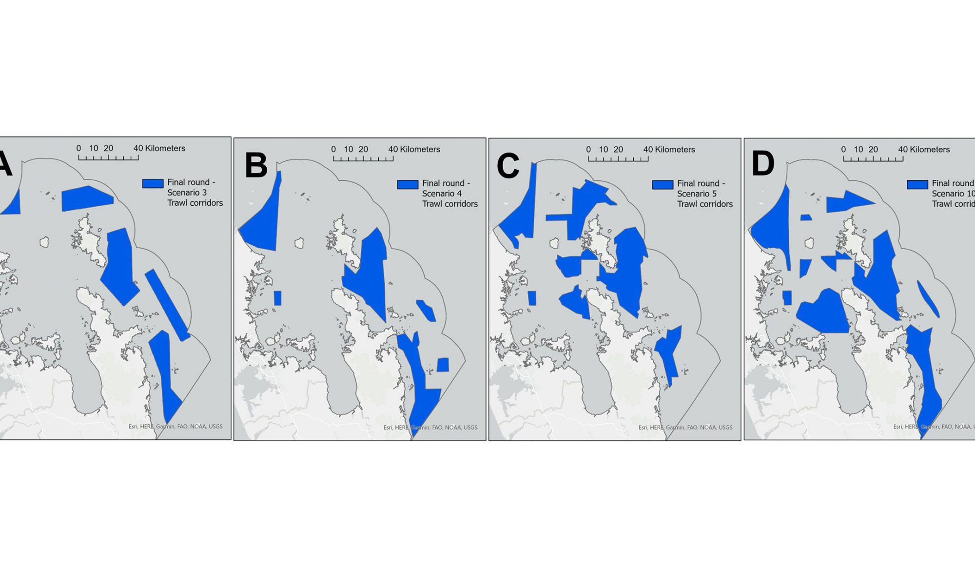
One difficulty I had was proposing trawl corridors. I decided not to volunteer a low impact scenario because the process had already generated a near zero impact scenario which I thought was reasonable (Similar to Figure 14C in the published report – 90% of recovery potential habitat and current trawl footprint & current/proposed protected areas and 100% of current distribution of biogenic habitat (minimising impacts on trawl fishery.) This meant I was left very unhappy with the scale of the proposed scenarios. It was obvious that the scenarios would need work before Fisheries NZ could designate corridors, however I may end up regretting that decision.

I hope Fisheries NZ will monitor recovery (which may take centuries) the data gained could help ground truth this model and develop more robust models in future.

You can read the published report on the design process here: Exploring the use of spatial decision support tools to identify trawl corridors in the Hauraki Gulf Marine Park

Advice for the Hauraki Gulf Fisheries Management Plan Working Group

The outputs of the process will be used by the Hauraki Gulf Fisheries Management Plan Working Group to design bottom trawling corridors in the marine park. Here are some key points they should be aware of:

  • Because the process is not ground truthed and does not account for secondary impacts, important habitats for fish or climate change impacts a precautionary approach should be taken. (I suggested massive buffers but they were deemed out of scope).
  • Danish seining impacts have not been included in the model. This skews the impacts, recovery in areas where this fishing method is practiced has been understated.
  • The corridors should be much deeper (further from the coast) to avoid the illegal transport of Unwanted Organisms.
  • Consider the existing Danish regulations as the starting point, not the area where the fishing method is currently practiced.
  • Protect the deeper areas of the Gulf because they are included in the Hauraki Gulf Marine Park (see appendix).
  • Include monitoring (fisheries method transition) in any recommendations.
  • Take special note of the sediment resuspension impacts detailed on page 68 of the report which were excluded from the study.

Appendix

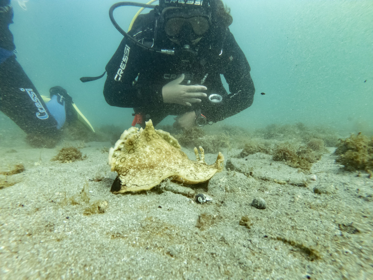
Avoiding tipa / scallop beds

Running heavy trawl gear over tipa / scallop beds is incredibly damaging and foolish behaviour. It not only damages the tipa including juveniles, but also the settlement substrates the tipa use as part of their lifecycle. The Review of Sustainability Measures for New Zealand scallops (SCA 1 & SCA CS) for 2022/23. 3.1.18 states that:

“Within the Hauraki Gulf Marine Park, overlap between trawl activity and scallop beds will be considered as part of the proposal to establish defined ‘trawl corridors’ that will limit the areas where bottom trawling can continue to operate. With the introduction of electronic reporting and Global Position Reporting (GPR) on commercial fishing vessels, Fisheries New Zealand has the ability, through fine scale data, to monitor any notable overlap between fisheries and methods.”

It was frustrating that even though tipa are the most surveyed biogenic habitat in the Gulf the fisheries scientists decided that instead of identifying them they would just model their associated habitats. In the paper they literally say they ‘hope’ that this would mean the beds would be avoided rather than just mapping them out. Only the small beds that remained open at the time of the study (the fishery has since collapsed with bottom impact fishing implicated as a key stressor) were removed from the study area.

The rationale for the exclusion of tipa was that they are very mobile. This is ridiculous given the grid size of the study is 250m. Adult tipa and burrowing animals are unlikely to move more than 10m in their lifetime. For adult tipa mobility see Morrison, M. A. (1999). Population dynamics of the scallop Pecten novaezelandiae in the Hauraki Gulf (Doctoral dissertation, ResearchSpace@ Auckland).

Danish seining regulations

The restrictions prescribed in fisheries regulations for Danish seining define a different area than what is currently applied by Fisheries NZ. The State of our Gulf 2020 quotes Fisheries  NZ as ‘committed to reviewing this discrepancy as part of management actions put forward in a fisheries plan for the Hauraki Gulf’. The discrepancy is not recorded in the final report.

Protecting the deeper areas of the HGMP

The deeper areas of the HGMP were excluded from the final scenarios. I asked that they be protected because:

  1. The edges of continental shelves are biodiversity hots spots. Predicted diversity along the depth incline is one of the reasons for excluding the area from the model.
  2. This process was designed to protect biodiversity.
  3. This is the only deep water area in a marine park in New Zealand.

Unwanted organisms discussion document

Here is the discussion document on an unwanted organism (Mediteranean fanworm) I prepared for the working group, similar logic could have been applied to other species including the two recently introduced Caulerpa species.

Omissions

The report details protection measures proposed by Sea Change 2017 but omits the most important benthic protection measure, “the phase out of all bottom trawling, Danish seining and scallop dredging from the Hauraki Gulf, with all such methods excluded by 2025” It’s a strange omission that reads like an attempt to exclude the measure from the history books.

Dredged to death

Fridays closure of the last two tipa / scallop beds in Aotearoa / New zealand will mark an historic moment for our fisheries. It signals the collapse of more than a fishery but an entire ecosystem. 

The last commercial mussel was dredged out of the Hauraki Gulf in 1966, after 56 years there are no signs of recovery. We don’t yet know what the fate will be for tipa. The fishery at the top of the South Island has been closed since 2017. If the tipa beds do not recover it will be the best evidence of ecocide in Aotearoa / New Zealand this century.

We need to change our ways. Both recreational and commercial dredging must be banned as per the Hauraki Gulf 2017 marine spatial plan that the government has still not acted on. These fishing methods damage the habitat that the animals grow in.

The result is:

  • Dead and damaged non target species and juvenile tipa
  • Lost biodiversity and water clearing animals
  • Lost habitats for fish especially juvenile fish
  • Long term changes to seafloor chemistry

The same impacts are created by other bottom impact fishing methods like bottom trawling and Danish seining which were also to be banned in the marine spatial plan. Short term fisheries closures are not good enough, we need a total ban on these methods.

Central government management actions to date have been irresponsible. Auckland Council did not take action when it was asked.

If the tipa beds do not recover naturally who will pay to restore them?

How to manage dogs in banned areas

Note this was written from the perspective on an average sized white male in his 40’s, you may need different tactics. The number one rule here is to never put yourself in danger.

Scenario 1. The dog is off-lead and there are threatened breeding birds in the area.

Chase after the dog. This shows the owners that something is really wrong, especially if you don’t look like the kind of person who likes to run. In my experience the dog usually returns to the owner, you can then have an (out of breath) conversation about why it’s important not to have dogs in the area.

Scenario 2. The dog is on a lead, there are no threatened breeding birds in the area.

Introduce yourself to the dog owners like you are an old friend. Be warm and in their face. This shows you are not somebody to be ignored but also not threatening. I like to shake their hand and tell them what I do here, my name, I also ask for theirs. Kindy explain to them that they must have missed the no dogs sign and send them back the way they came. It’s a good idea to walk with them as this shows how serious you are. Asking them about their dog(s) helps you come across as relatable, it’s also useful to find out if they are a local.

Scenario 3. Dealing with repeat offenders.

I have actually never had this problem but I received this advice from Auckland Council after having an argument with a local who was determined he was allowed to walk his dog somewhere where he was not.

1. Record the offenders details.

  • Ideally you already have their name from Scenario 2, if not ask for it again in a friendly way and apologies for forgetting.
  • Get a description of the dog (its breed, colour, sex, size etc and a description of the collar).
  • If the dog is not with its owner and it is safe to do so you might be able to get its tag details, for this you want the tag number and expiry date.
  • You might be able to get a photo of the owner or dog.
  • You might also be able to follow them to their car or house to record a license plate or address – but never put yourself in danger.

2. Report the details to Auckland Council (09) 301 0101 with the time, date and location. You will also need to report your contact details.

If Council officers are able to locate the owner an infringement may be issued. Keep a record of the incident for yourself. If there are regular incidents you can ask Council to do monitoring. In this case someone from the animal management team will visit the reserve. My understanding is that they can issue infringement notices on the spot.

Unprofessional editorial

An open letter to Keith Ingram.

In your July / August 2022 issue of Professional Skipper you ran an editorial titled How important are marine reserves?. You made a bunch of incorrect statements that I thought someone else would correct but I’m told the latest issue does not include any retractions. I have corrected them here:

“Recent statements by prominent yachties Peter Burling and Blair Tuke on Behalf of Living Ocean calling for 30 percent of the Hauraki Gulf to be under marine protection by 2030 are totally ill-founded”

The organisation is called Live Ocean not Living Ocean.

The statement is well founded by the 30×30 goal and the Hauraki Gulf Forums 30% goal which would leave 70% of the Gulf for fishing.

You go on to criticise the marine reserve proposed for Northwest Waiheke without pointing out a single problem with the application. You also ask what this group has in mind. Here is the application.

You claim there was “secrecy” but according to this statement from the Friends of the Gulf the application process was in plain sight and far from secret.

[After submitting the draft application for the Hākaimangō – Matiatia Marine Reserve to the Director-General of DOC and simultaneously to the two Ngāti Paoa Trust Boards a month was allowed for their unlobbied consideration. FOHG then went public with presentations to the Waiheke Local Board, The Local Piritahi Marae, Hauraki Gulf Forum, neighbouring property owners, other community organisations both on and off-island and articles, letters and advertisements in the Waiheke local newspapers The Gulf News and The Weekender and widely published on social media, national news media and radio. Following 10 months of pre-notification consultation, the revised application was lodged, advertised in all the main centre daily newspapers and distributed with two months allowed for public submissions or objections. This drew 1,303 public submissions. 1,183 were in full support.]

“Charterboat catch data is hugely valuable in showing how productive the gulf is at the moment and what it was like over the past 20 years, which I suggest is very different to the negative assessments of the state of the Hauraki Gulf that the environmentalists typically publish”

It’s not logical to decide the state of an ecosystem the size of the Hauraki Gulf Marine park using a single source of data like ‘charterboat catch’. The state of the environment reports are required every three years under the Hauraki Gulf Marine Park Act. They cover a broad range of indicators and massive data sets.

“Some recent nasty marine invaders that have adapted to our waters include the Asian paddle crab, the Chinese mitten crab, Stela clava. the Mediterranean tube worm. the Asian nesting clam, Caulerpa taxifolia and Undaria (Japanese kelp).”

There are no Chinese mitten crabs or Asian clams in Aotearoa / New Zealand, if you do find either of these species please phone Biosecurity NZ (0800 80 99 66) immediately.

You say: “Locking up marine areas won’t solve these problems” Marine reserves are more resilient to climate change impacts including invasive species because there are no gaps in the ecosystem created by overfishing. They can also help overfished areas recover after a pollution or climate event because they have more old animals that make a disproportionate contribution to recruitment. Here are some graphics I produced to explain the concepts.

Marine heatwaves are creating local extinctions The role of MPA's in climate change
It takes thirty six 30cm snapper to make the same amount of eggs as one 70cm snapper.

Let me know if you need more examples.

“Marine Protected Areas are not a fisheries management tool.”

I agree MPAs are a conservation tool, but MPA’s can also have fisheries benefits. For example this research from the University of Auckland and NIWA estimates that spawn originating in the small Marine Reserve at Leigh contributed “commercial fishery of $NZ 1.49 million catch landing value per annum and $NZ 3.21 million added from recreational fishing activity associated spending per annum” (Qu et al. 2021). The short term loses are offset by future gains. It will be interesting to see if Fisheries New Zealand take a long term view of the proposal in their impact assessment. I suggest you read this great article by Good Fishing which looks at the proposed High Protection Areas.

“The marine reserve legislation administered by DoC prohibits … the movement of vessels carrying flora and fauna through MPAs or reserves.”

This is inncorrect.

“An amendment to the Fisheries Act could provide for… the same result as Marine Reserves”

Unfortunately this won’t help as the agency has been captured by industry. One new tool we can use is the RMA which gives areas a break from fishing 10 years at a time. It’s disappointing that Legasea have not embraced the tool, which can stop bottom impact fishing once it is in discrete areas (for example ‘corridors’).

“We need honest, sound and reasonable leadership in this debate”

Agreed, if you want help fact checking any future editorials about marine biodiversity I would be happy to help.

Careless statements from NZUA

The New Zealand Underwater Association’s (NZUA’s) Annual report is out with lots of stunning photos from Experiencing Marine Reserves. I do a lot of diving but I’m not a member of NZUA. One of the reasons for this is the associations close relationship with the blood sport organisations (New Zealand Sports Fishing Council / Legasea and The NZ Spearfishing Association).

Environmental campaigns are one of its three pillars but the organisations moral compass is compromised by support for activities that kill our native wildlife. They have been more political recently (lobbying government on fishing policy) but they aren’t developing their own views, just kowtowing to Legasea.

On page 26 of the Annual Report they have said they will be consulting on new Marine Protection Areas (MPAs) and that they support them, but they give some uninformed caveats.

We don’t support MPAs where:

1)  An area is not of ecologically significant (This is the exact wording, not a typo from me)

This is an illogical statement because we need to protect a network of representative habitats from fishing. In Aotearoa / New Zealand less than a one percent of our marine environment is protected from fishing, so nearly any protected areas will become ecologically significant.

2) Where removing an area concentrates fishing effort elsewhere

All place based fishing protection displaces fishing effort, including those that limit commercial fishing. It’s a short term loss that is offset by the long term benefits of having an area with larger breeding animals which produce exponentially more offspring. For example it takes thirty six 30cm Tāmure / Snapper to make the same amount of eggs as one 70cm fish (Willis et. al., 2003). And of course the spillover effect which I should not have to explain.

Most divers and the New Zealand public understand this, which is why marine reserves are so popular. There is 77% support for 30% marine protection in the Hauraki Gulf Marine Park and 93% of the submissions for a recent marine reserve proposal for Waiheke Island were supportive, despite opposition from the blood sport lobby groups.

Despite our Marine Reserves being the best places to dive, NZUA say that ‘instead’ they will now support Special Marine Areas (SMAs). They then confuse the term as used in Revitalising the Gulf: Government action on the Sea Change Plan and tell readers that SMA’s include the mussel beds that I have been helping to make (which are not protected from human harvest), seaweed reestablishment and crayfish re-introduction. However these are all examples of active restoration – which I am a big fan of – but it’s really hard, small scale and expensive. Active restoration has its own work stream in the plan and is completely different to SMAs. In the Sea Change – Tai Timu Tai Pari marine spatial plan SMAs are Special Management Areas, they are described as “limiting all commercial fishing, and in addition the restrictions would extend to most recreational fishing (with the exception allowing for ‘low volume/high value’ catch)” They were proposed for the Mokohinau and Alderman Islands. Without strong limits on recreational fishing I expect the SMAs would have failed to create conservation outcomes in a similar fashion to Mimiwhangata. The experts have redesigned them as High Protection Areas (HPAs). The experts decided the SMAs (like Rāhui expressed as section 186 closures) are fisheries management tools rather than conservation tools. It will be interesting to see if DOC can get them to meet the International Union for Conservation of Nature’s (IUCN’s) high protections standards. Assuming these are the SMAs NZUA refer to, the SMAs would not have meet their own criteria (as an MPA that they are willing to support) because they would have displaced fishing effort.

By using the wrong terminology and examples, we can see NZUA have not paid much attention to the statements. The uninformed caveats for MPAs they would support show a general lack of awareness of ocean conservation. I hope they clarify their position. It sounds like NZUA and the blood sport groups will oppose the HPAs proposed in Revitalising the Gulf. This is disappointing, without more support NZ will stay in the 1% protection level along with Russia and China. See how marine protection in Aotearoa / New Zealand stands on the international stage in this awesome graphic by NZ Geographic.

NZUA are falling out of step with the New Zealand public and drifting away from their international counterparts who are strong ocean advocates. Divers have a unique view of the underwater world, I believe it comes with a responsibility to take care of it. I wish NZUA were more like PADI who are working to protect 30% of our oceans. SSI are also active in Aotearoa / New Zealand with a no harm Marine Conservation programme.

I hope NZUA one day learn to take the same precautionary care for the health of our oceans that they advocate for in diver safety.

Pāpaka

An open letter to the Minister for Oceans and Fisheries.


Hon David Parker
Minister for Oceans and Fisheries
d.parker@ministers.govt.nz

11 May 2022

Tēnā koe Minister Parker

Pāpaka / Paddle Crabs (Ovalipes catharus) are native to New Zealand. There are 10 commercial fishery areas with nearly all the catch on the East coast of the North Island. The commercial catch has been in decline for two decades with no changes to the Total Allowable Commercial Catch (TACC). The TACC is about ten times larger than the recreational and customary catch. The main fisheries (PAD 1, 2, 3, 7, 8) look like they may have collapsed, the TACC for these fisheries total 590 tonnes, landings in the 2019-20 season were only 19.2 tonnes (3% of the TACC).

I disagree that the fishery is only lightly exploited (FNZ 2021).

Commercial paddle crab landings (tonnes)

Please research the current population. If you don’t have the resources to do this then I recommend you:

  1. Dramatically reduce the TACC for Pāpaka to allow the species to recover.
  2. Reduce the daily bag limit from 50 to 5.
  3. Ban the use of nets in estuaries which kill Pāpaka and other declining species as bycatch.

Thank you

References

FNZ 2021. PADDLE CRABS (PAD) https://fs.fish.govt.nz/Doc/25060/55%20PAD%202021.pdf.ashx

UPDATE 19 August

Response from Hon David Parker.

The response leaves catch limits incredibly high (765 tonnes for commercial) despite acknowledging that commercial take is incredibly low. The minister assumes that the population is healthy but provides no data to justify the decision.

An underwater time machine for Waiheke Island

On an ordinary part of our coastline in 1975 our first marine reserve was created. The Cape Rodney-Okakari Point Marine Reserve at Leigh was difficult taking 13 years to overcome all the objections from fishers. 47 years on what have we learnt?

We now know the sacrifices those fishers made has been paid back a hundred fold. The reserve is home to large fish which make a disproportionate contribution to the Gulf Tāmure / Snapper population. It takes thirty six 30cm Tāmure / Snapper to make the same amount of eggs as one 70cm Tāmure / Snapper. Adult Tāmure / Snapper within the reserve at Leigh were estimated to contribute 10.6% of newly settled juveniles to the surrounding 400km2 area, with no decreasing trend up to 40km away. The commercial value of the nursey has been estimated at $1,490,000 per annum. That’s a huge contribution and it makes you wonder how bad things would be without the reserve, what’s worse we might not even know how bad it had gotten.

The marine reserve at Leigh was designed to act as a benchmark, a view of what an unimpacted ecosystem would look like. It’s the best place to experience marine wildlife. The fish are big and abundant, the water is alive and exciting. Putting your head underwater is like looking back in time when the ocean was healthier.

With every passing generation we lose memories of abundance and diversity. When I wonder if I saw more seahorses as a child I can’t be sure. This is the value of having a reference point to measure marine health.

Our marine scientists now understand edge effects, population source & sink dynamics and the connections between geology, habitat and biodiversity. They understand how intact ecosystems are more resilient to pollution and change. At 2,350ha the new Waiheke marine reserve is four times the size of the Leigh marine reserve (547ha). I think it will out perform the Leigh marine reserve and deliver our best chance of experiencing an intact marine ecosystem in the inner Gulf. It could be a benchmark, the gold standard to which we measure other changes we make.

There will be many additional benefits for the Waiheke marine ecosystem like protecting against overfishing and improving the resilience in the face of climate change and pollution. But it’s the reserves function as an experience of unimpacted ecosystem, a window back in time, not just to 1975 but further back before human impact, that’s what we hope to discover.

But this time machine won’t happen without your support. Please visit https://www.doc.govt.nz/waihekeproposal/ and let the decision makers know what excites you about the proposal.

New Zealand’s crazy fishing rules

With the government reviewing the Wildlife Act 1953 I got to thinking about our wild fish. The rules are pretty crazy.

I definitely think its time for a review.

Link to high res portrait version of this diagram.

Why I’m supporting the Waiheke Marine Reserve proposal

Here is my submission on the Hākaimangō – Matiatia Marine Reserve (Northwest Waiheke Island) application. Details and submission form here. Feel free to use any or all of this submission yourself and send it to: waihekeproposal@publicvoice.co.nz


There have been decades of korero about marine protection in the Hauraki Gulf / Tīkapa Moana / Te Moananui-ā-Toi. Everyone knows we urgently need more protection but the Governments proposals are too small, experimental, slow and ignore Waiheke Island.

The only concern I have about the Hākaimangō – Matiatia Marine Reserve (Northwest Waiheke Island) application is the lack of published support from iwi authorities. My understanding is that the applicants and the Department of Conservation continue to engage iwi (nine months to date), but while iwi authorities at this stage have not committed their support they are interested in dialogue and importantly they have not opposed the application. Two leading descendants of 19th century Waiheke Ngāti Paoa chiefs, Moana Clarke and Denny Thompson have expressed open support. Iwi politics in the Treaty settlement era are complex and difficult for me as a pakeha to understand. I am concerned about the considerable expectations put on Māori. If we limit our support to co-designed or iwi led marine reserve applications we would be burdening iwi with a responsibility for marine heath they do not seem to be resourced to implement. There are no published concerns about the proposal from iwi. 77% of Māori support 30% marine protection in the Gulf (Hauraki Gulf Forum Poll 2021). I hope that the iwi leaders will put the mauri / lifeforce of the HGMP first and support the application. In the meantime the cautious approach of iwi authorities is no reason not to support the application. If any iwi do have concerns we should take great care to hear and work through those concerns, they have significant rights as mana moana.

UPDATE 28 February. A local iwi body the Ngāti Paoa Trust Board are supporting the application.

16 reasons I’m supporting the Hākaimangō – Matiatia Marine Reserve (Northwest Waiheke Island)

1. We don’t have enough protection. A tiny 0.33% of the Hauraki Gulf Marine Park (HGMP) is fully protected from fishing, the governments Revitalising the Gulf plan will hopefully increase this area to 0.575% by late 2024 (Revitalising the Gulf 2021). The other forms of protection suggested in the plan all involve some kind of fishing. We need places where with intact ecosystems where our taonga and heritage don’t get eaten. The proposed Hākaimangō – Matiatia Marine Reserve is a significant addition at 0.195% of the HGMP. All the proposed protections need to be actioned as soon as possible to reverse the decline of biodiversity and abundance in the HGMP (State of our Gulf 2020). If all the proposals are accepted only 6.7% of the HGMP will be protected from fishing (excluding cable zones which are not designed to protect biodiversity). We will need many more proposals to meet the Hauraki Gulf Forums goal of 30% protected.

2. It’s long term. Rāhui enacted through section 186 of the Fisheries Act only last for two years. This is not the right tool to use to sustain large breeding animals live for more than 50years. Tāmure / Snapper can live to at least 60 years of age (Parsons et. al. 2014).

3. It’s big. For decades scientists have been telling us that our marine reserves are not big enough to protect wildlife from the edge effect. If approved at 2,350 ha Hākaimangō – Matiatia would be the largest marine reserve in the HGMP.

4. It’s in a great spot. The site covers an ecological transition zone between the waters of the inner and outer Gulf. The inner Gulf is slightly cooler, more turbid, shallower, low energy (sheltered by a screen of islands including Waiheke Island) compared to the outer Gulf which is deeper, warmer, clearer and comparatively high energy marine environment. The site was select by marine biologist Dr Tim Haggitt after doing extensive surveys around Waiheke Island in 2015. The area is geologically remarkable for its extensive underwater platforms and terraces, the diversity in physical habitat is reflected in the flora and fauna.

5. There are plants and animals left worth protecting. Functionally extinct species like Kōura / Crayfish (Jasus edwardsii & Jasus verreauxi) are still found in the area so the recovery time here will be faster than other overfished areas of the HGMP.

6. We need more baby fish. It takes thirty six 30cm Tāmure / Snapper to make the same amount of eggs as one 70cm fish (Willis et. al., 2003). This marine reserve would dramatically increase egg production in the HGMP. Marine reserves make a disproportionate (2,330% Tāmure / Snapper in the reserve at Leigh) larvae spillover. Adult Tāmure / Snapper within the reserve at Leigh were estimated to contribute 10.6% of newly settled juveniles to the surrounding 400km2 area, with no decreasing trend up to 40km away (State of our Gulf 2020).

A 40km radius from the centre of the proposed marine reserve.

7. Fishing on the boundary will be awesome. The proposed marine reserve is big enough for people to fish the borders with a clear conscience. Fishing here will be popular with many big fish leaving the area (See Halpern et. al. 2009 on spillover).

8. People want marine reserves. Marine reserve support is strong and getting stronger. On island support for marine protected areas from island residents was 67% with off-island ratepayers at 54% in 2015. A 2021 poll by the Hauraki Gulf Forum shows general support for 30% protection at 77% with only 5% opposition. The poll showed no difference in support from Māori.

9. It’s a great cultural fit. Most people who live on Waiheke Island really care about the environment. Conservation values are strong across the different local communities.

10. It will be great for education. The marine reserve will create much richer outdoor education opportunities for the young and old people of Waiheke and Auckland. Rangitahi in particular will benefit from being able to experience an intact marine ecosystem. Te Matuku Marine Reserve is less suitable for education because the water clarity is dramatically impacted by sediment.

Left: Diver at high tide in the Te Matuku Marine Reserve.
Right: Wheke / Sydeny Octopus at high tide in the proposed marine reserve.
Photos by Shaun Lee.

11. Resilience to climate change. By maximising biodiversity and abundance the marine reserve will protect the HGMP from climate change impacts, particularly heatwaves, invasive species and ocean acidification. Marine reserves are like insurance against uncertainty.

Marine heatwaves are causing local extinctions

12. Improving the economy via commercial fisheries. Juvenile Tāmure / Snapper leaving the Cape Rodney to Okakari Point (Goat Island/Leigh) Marine Reserve boosted the commercial fishery by $NZ 1.49 million per annum (Qu et. al. 2021). Auckland University found 10.6% of juvenile snapper found throughout the Gulf – up to 55 km away were sourced from this one marine reserve. The researchers found economic benefits to the recreational fishery are even more substantial.  There are other commercially fished species in the area. The proposed marine reserve is four times bigger than the Goat Island reserve.

13. A benchmark. No harm marine reserves provide a reference point for assessing the impacts of our activities elsewhere. “As kaitiaki in the broadest sense, we have an obligation to preserve natural examples of marine ecosystems” – State of our Gulf 2020. Data obtained from marine reserve monitoring compliments fisheries information and matauranga Māori to help us understand environmental change.

14. Science. Marine reserves are a natural laboratory. They have contributed massively to our understanding of marine ecology and ecological processes. Many of our leading marine scientist studied and conducted research in marine reserves at Leigh, Tāwharanui, Hahei and elsewhere. Of course the Marine Reserves Act expressly recognises the scientific importance of marine reserves. Scientific research is an over-riding priority in the Act,

15. Tourism benefits. The marine reserve will add to the growing ecotourism opportunities on Waiheke Island. It complements the $10.9 million dollar investment in Predator Free Waiheke (Predator Free 2050 Limited 2021) which has a vision to become the world’s largest predator-free urban island. The marine reserve will be much cheaper to create and maintain and will deliver a mountains to the sea nature experience.

16. Return on investment. The Cape Rodney to Okakari Point Marine Reserve (Goat Island) generated $18.6 million for the local economy in 2008 at a cost of about $70,000 for the Department of Conservation (State of our Gulf 2020).

The Hauraki Gulf / Tīkapa Moana / Te Moananui-ā-Toi can not afford to have this application sit on a shelf waiting for stronger political leaders. Please start the process of creating the Hākaimangō – Matiatia Marine Reserve and healing the wider area as soon as possible.


References

Hākaimangō – Matiatia Marine Reserve (Northwest Waiheke Island) https://friendsofhaurakigulf.nz/

Hauraki Gulf Forum Poll 2021. https://gulfjournal.org.nz/2021/11/results-of-hauraki-gulf-poll/

Parsons DM, Sim-Smith CJ, Cryer M, Francis MP, Hartill B, Jones EG, Port A Le, Lowe M, McKenzie J, Morrison M, Paul LJ, Radford C, Ross PM, Spong KT, Trnski T, Usmar N, Walsh C & Zeldis J. (2014). Snapper (Chrysophrys auratus): a review of life history and key vulnerabilities in New Zealand, New Zealand Journal of Marine and Freshwater Research, 48:2, 256-283, https://doi.org/10.1080/00288330.2014.892013

Predator Free 2050 Limited 2021. Annual Report 2021 https://pf2050.co.nz/predator-free-2050-limited/

Revitalising the Gulf 2021 https://www.doc.govt.nz/our-work/sea-change-hauraki-gulf-marine-spatial-plan/

State of our Gulf 2020 https://gulfjournal.org.nz/wp-content/uploads/2020/02/State-of-our-Gulf-2020.pdf

Qu et. al. (2021). Zoe Qu, Simon Thrush, Darren Parsons, Nicolas Lewis. Economic valuation of the snapper recruitment effect from a well-established temperate no-take marine reserve on adjacent fisheries. Marine Policy. Volume 134. https://doi.org/10.1016/j.marpol.2021.104792

Willis, T.J., Millar, R.B. and Babcock, R.C. (2003), Protection of exploited fish in temperate regions: high density and biomass of snapper Pagrus auratus (Sparidae) in northern New Zealand marine reserves. Journal of Applied Ecology, 40: 214-227. https://doi.org/10.1046/j.1365-2664.2003.00775.x

Halpern, B., Lester, S., & Kellner, J. (2009). Spillover from marine reserves and the replenishment of fished stocks. Environmental Conservation, 36(4), 268-276. https://doi.org/10.1017/S0376892910000032