I made these graphics for Auckland Council to show people how to make healthier and more resilient waterways. It’s awesome to see informed leadership on attitudes to rural and urban land use.


Mostly just stuff I am doing to help the planet

I made these graphics for Auckland Council to show people how to make healthier and more resilient waterways. It’s awesome to see informed leadership on attitudes to rural and urban land use.
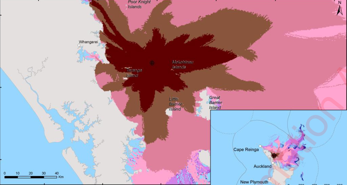
I asked Maritime NZ for the oil spill trajectory modelling from the wreck of the RMS Niagara. I have uploaded it here for anyone interested.
My layman’s notes below:
MNZ have kindly tried to explain it to me, but I don’t really understand why the 2016 modelling was only done with about 97 tonnes of oil (100 m³) when the Rena leaked 350 tonnes. The RMS Niagara could store more than 4,000 tonnes of oil and experts have estimated that there could be 1,400 tonnes remaining. This means the estimated volume of oil on individual beaches and the length of shoreline impacted could be dramatically worse.
The probability of oil contact with the shoreline increases by 10% if it happens in summer (This is tara iti / New Zealand fairy tern breeding season, we are down to nine breeding female left, note the Rena spill killed 2,000 birds). The impacts move a bit further south in winter.
It’s interesting to see the areas impacted. The spill expands outward from the wreck largely as you would expect, but there are interesting details. For example, it will be twice as bad at Goat Island than further up the coast at Mangawhai. If it’s going to be visible at the Mokohinau Islands in just a few hours, I think it might be a good idea to install a webcam there.
Harbours and bays are less impacted, but I wonder if this is an artefact of the modelling software. It definitely shows that even a 97-tonne spill will span a massive length of our coastline. For example, Waikato Regional Council also needs to be prepared.
I’d like a better understanding of the risk and the mentioned contingency plan. It would be helpful to run scenarios with different response times, gear, and methods; this may have already been done.
UPDATE: 10 Dec 2024. I asked Maritime NZ for costings for Stage 2 of the survey of the RMS Niagara wreck. Summary: The estimated cost for Stage 2 of the RMS Niagara wreck survey totals NZ$13.74 million, split into two parts. Part 1 involves a visual survey using a remotely operated vehicle (NZ$1.3 million). Part 2, requiring a dynamic positioning vessel due to proximity to submarine cables, includes hull cleaning, oil level measurement, and risk assessment (NZ$12.44 million). A moored vessel alternative for Part 2 costs NZ$4.5 million but is not recommended due to the risk to undersea cables. An additional NZ$500,000 is estimated for oil pollution response readiness during the survey.

After finding a green sea turtle in Devonport and reading about leatherback sea turtle bycatch I decided to do some research on what was going on with turtles in New Zealand. I made a graphic summary.

Big thanks to Clinton Duffy for the review.

Artificial reefs have significant potential to boost fish populations, even surpassing pre-fished levels or what is possible in marine reserves. However they have a checkered history overseas, with many reefs:
When considering building an artificial reef, it is crucial to determine whether it will provide additional habitat to support reef communities or merely function as a Fish Aggregation Device (FAD). Like artificial reefs, FADs are man-made structures which are attract fish to a specific area by providing habitat and shelter for marine life. The problem with FADs is that they decrease local fish populations by concentrating them in one area where they are easily targeted by fishers (Cabral et al. 2014) as illustrated below.

To define the size of the habitat required to avoid FAD functionality, you could base it on the home range of each fish species you want to increase. For example:
The most studied fish in the Hauraki Gulf is the tāmure / snapper, which show high site fidelity to reef habitats. Tāmure in deep soft sediment habitats are quite mobile, with a median distance of 19 km, and some movements up to 400 km. In contrast tāmure in shallow rocky reef habitats have restricted movements, with a median distance of 0.7 km (Parsons et al. 2011). You can see this in small marine reserves with shallow rock reefs, such as the 5 km² Cape Rodney – Okakari Point Marine Reserve (Goat Island), which effectively increase the size and abundance of this species. Additionally, tāmure around mussel farms have been found to be healthier than those in surrounding soft sediment habitats (Underwood 2023). The studied mussel farms were near rocky reefs and covered about eight hectares (200 x 400m).
This means fished artificial reefs should be deployed at hectare scales to avoid acting as population sinks. For tāmure, an area about the size of eight rugby fields is a considerable undertaking, but to avoid your reef functioning as a FAD for fishing, it is essential to spread your structure over a large area. If this sounds more like ‘habitat enhancement’ than an artificial reef, then perhaps that is a better way to frame your design. Of course, this consideration is unnecessary if your artificial reef is not fished.
REFERNCES
Bracho-Villavicencio et al., 2023 https://doi.org/10.3390/environments10070121 A Review of the State of the Art and a Meta-Analysis of Its Effectiveness for the Restoration of Marine Ecosystems. Environments.
Cabral et al., 2014 https://academic.oup.com/icesjms/article/71/7/1750/664488 Modelling the impacts of fish aggregating devices (FADs) and fish enhancing devices (FEDs) and their implications for managing small-scale fishery
Gauff et al., 2023 https://doi.org/10.1016/j.jembe.2023.151882
Unexpected biotic homogenization masks the effect of a pollution gradient on local variability of community structure in a marine urban environment.
Parsons et al., 2003 https://www.researchgate.net/publication/225304000_Snapper_Pagrus_auratus_Sparidae_home_range_dynamics_Acoustic_tagging_studies_in_a_marine_reserve Snapper Pagrus auratus (Sparidae) home range dynamics: Acoustic tagging studies in a marine reserve
UnderwaterTimes.com 2006
https://web.archive.org/web/20170912095117/https://www.underwatertimes.com/news.php?article_id=36210951740 Two Million Tire Artificial Reef to be Removed Off Florida Coast; Smothering Corals
Underwood et al., 2023 https://www.aquaculturescience.org/content/dam/tnc/nature/en/documents/aquaculture/AquacultureHabitatComparativeReport.pdf Habitat value of green-lipped mussel farms for fish in northern Aotearoa New Zealand
Zhang et al., 2019 https://doi.org/10.1016/j.scitotenv.2019.134768
Microplastic pollution in water, sediment, and fish from artificial reefs around the Ma’an Archipelago, Shengsi, China.

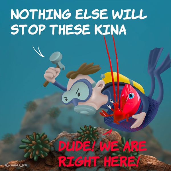
In an article titled “Shane Jones sets sights on killer kina – An industrial grade problem” the Fisheries Minister Shane Jones is quoted as saying “Some ecologists say it’s related to overfishing but the evidence is not conclusive in that regard. From my perspective as Fisheries Minister, I can provide some practical tools through the law, to allow local communities to go and cull them.”
The consultation document on the proposed tool provides a definition of kina barrens and clearly explains they are formed by a “low abundance of predator species“.
I was concerned that our Fisheries Minister could be so poorly informed so I asked Fisheries New Zealand for:
Fisheries New Zealand replied in detail today with recent information that has been provided to the Minister with respect to kina and kina barrens (note I have run the scanned pages through a text recognition software).
Fisheries New Zealand have clearly supplied conclusive evidence that kina barrens are related to overfishing. They have not supplied any research findings that corroborate the Minister’s statement that the cause of kina barens is inconclusive. I don’t know where Shane Jones is getting his alternative facts.
Of interest (and to his credit) Shane Jones has asked staff to increase the pace on starting pre-engagement to identify voluntary and/or regulatory measures to support increased large rock lobster abundance in areas with kina barrens (p25, detail on p21). Progress on this workstream seems to have been withheld and its clearly delayed as the other (extractive) measures mentioned have been consulted on. Two new measures that staff have suggested include a Maximum Legal Size Limit for Lobster and ‘Catch Spreading’.
While we wait for government action, millions of kina relentlessly devour our kelp forests.


There is some confusion about the change in these numbers because of the way the data was reported. I made this graphic to also clear up that as of April 2024 there is no data that has been made public from the on-board cameras for commercial fishing vessels programme.
Data sources: Overview of the rollout of on-board cameras on commercial fishing vessels February 2024 Update at 1 April 2024: Progress on the rollout

This summer Tōrea pango / Variable Oystercatcher have nested for the first time at Tahuna Torea Nature Reserve (written records began in the 1970’s). Its also the first time any bird has nested on the man-made shorebird roosts (or islands) in the lagoon. Tōrea Pango are recovering from being threatened with extinction and are one of the most endangered breeding birds in the Eastern Songbird Project area. The nearest breeding area is Motukorea / Browns Island which is a population sink for the species. The reserves name ‘torea’ does not come from this species but the South Island Pied Oystercatcher which once gathered here in great numbers.
The two egg nest was laid days after I trimmed the vegetation on Kuaka Island mid November 2023 as part of a roost restoration project. A team of local bird watchers kept a close eye on the nest. The mud in the lagoon keeps the cats out, but not the rats, the trapping team stepped up efforts and rats stopped turning up on the trail camera. One of the eggs was not fertile but the other one was and the bird watching team was thrilled when a chick hatched just in time for Christmas.
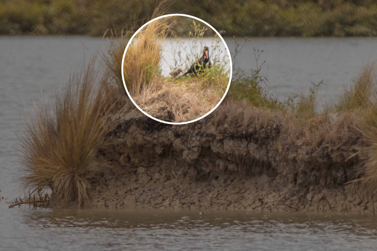
The nest would not likely have survived a kiteboarding event in the lagoon. Thanks to the kiteboarders for volunteering to stop kiting in the lagoon at high tide. If you do see anyone kiting in the lagoon phone me 021 555 425 and I’ll have a chat to them.

It was interesting that after nesting on Kuaka Island where I had trimmed vegetation and where a small amount of mangroves have been removed (not the majority) the parents then took the chick 400 m southeast to Cable Beacon Point. New mangrove stumps here were used by the chick to hide. I put up a sign and the bird watchers were on high alert for a few weeks until the chick fledged. The Tōrea pango whanau have stayed in the area which is a great endorsement of the reserve from our feathered friends and a huge win for our shorebird habitat restoration efforts.

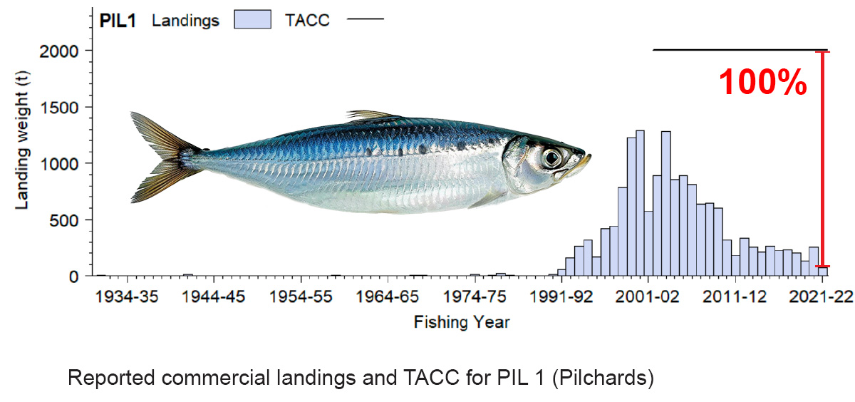
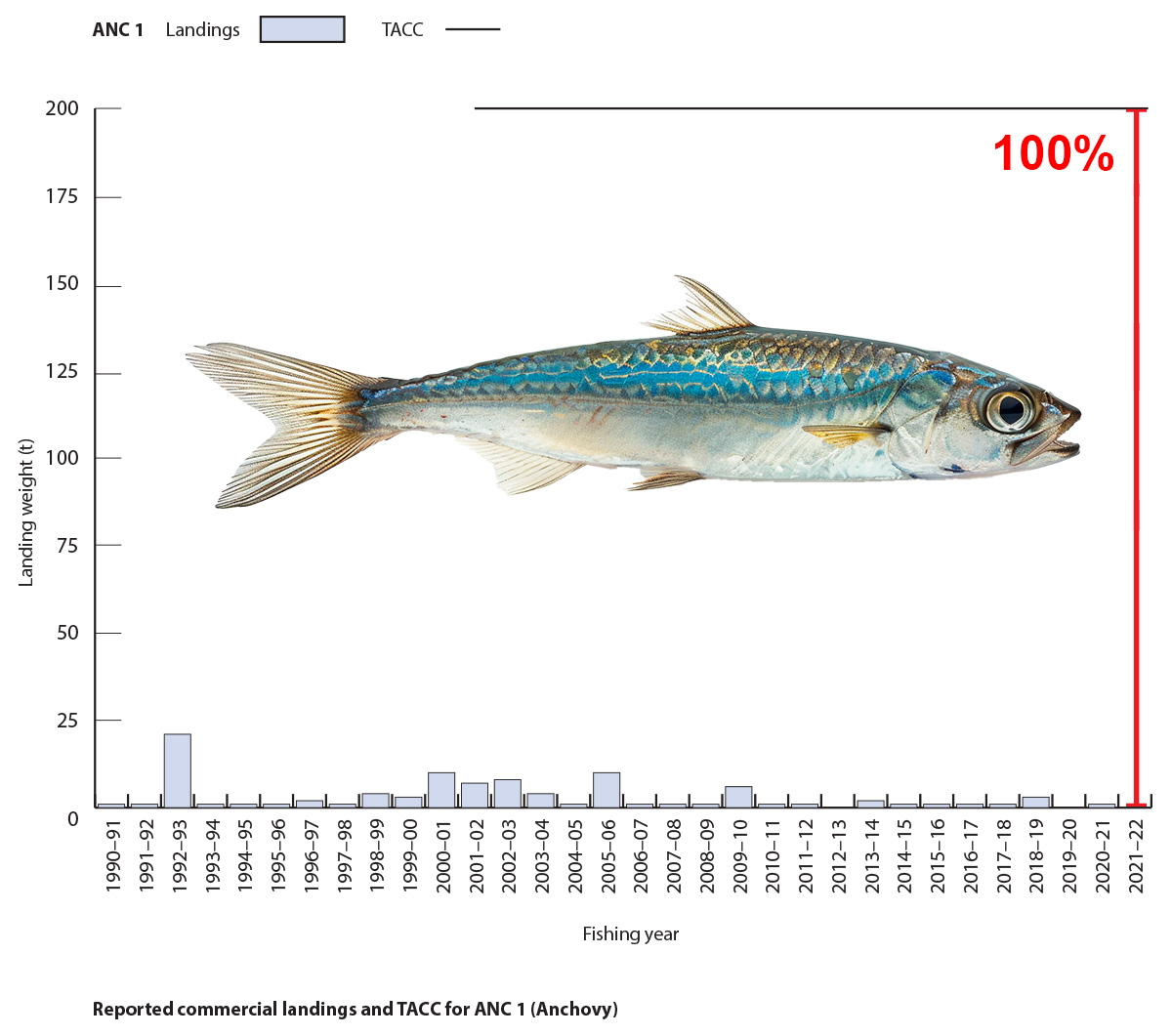
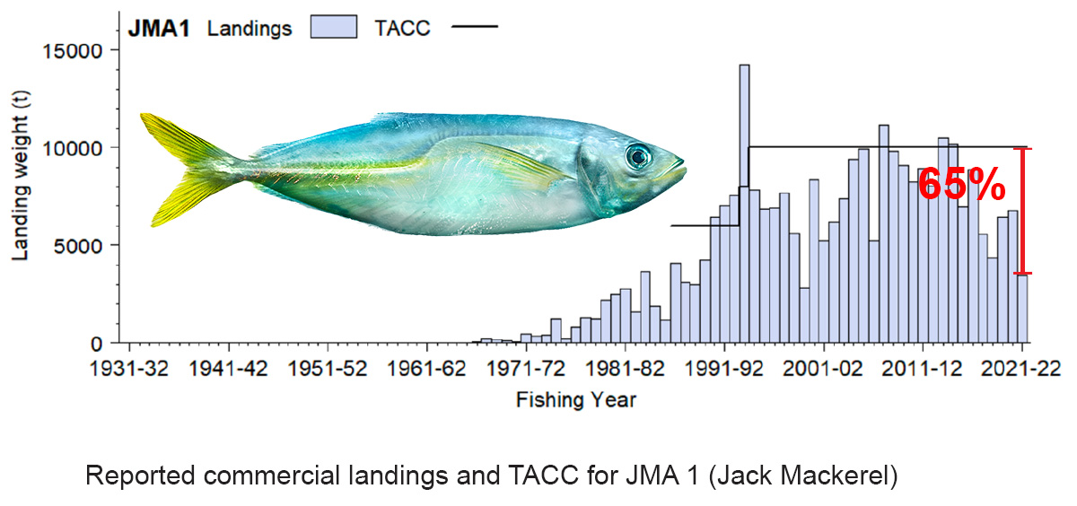
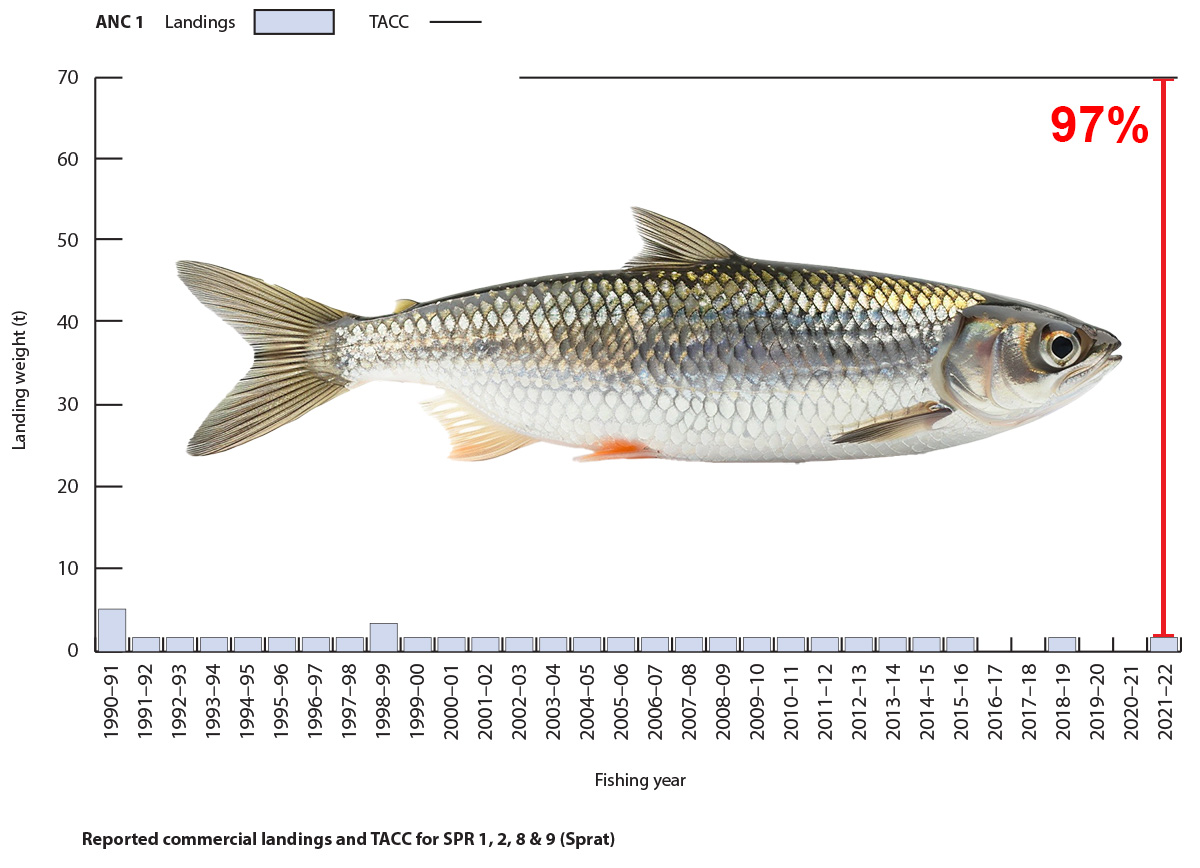
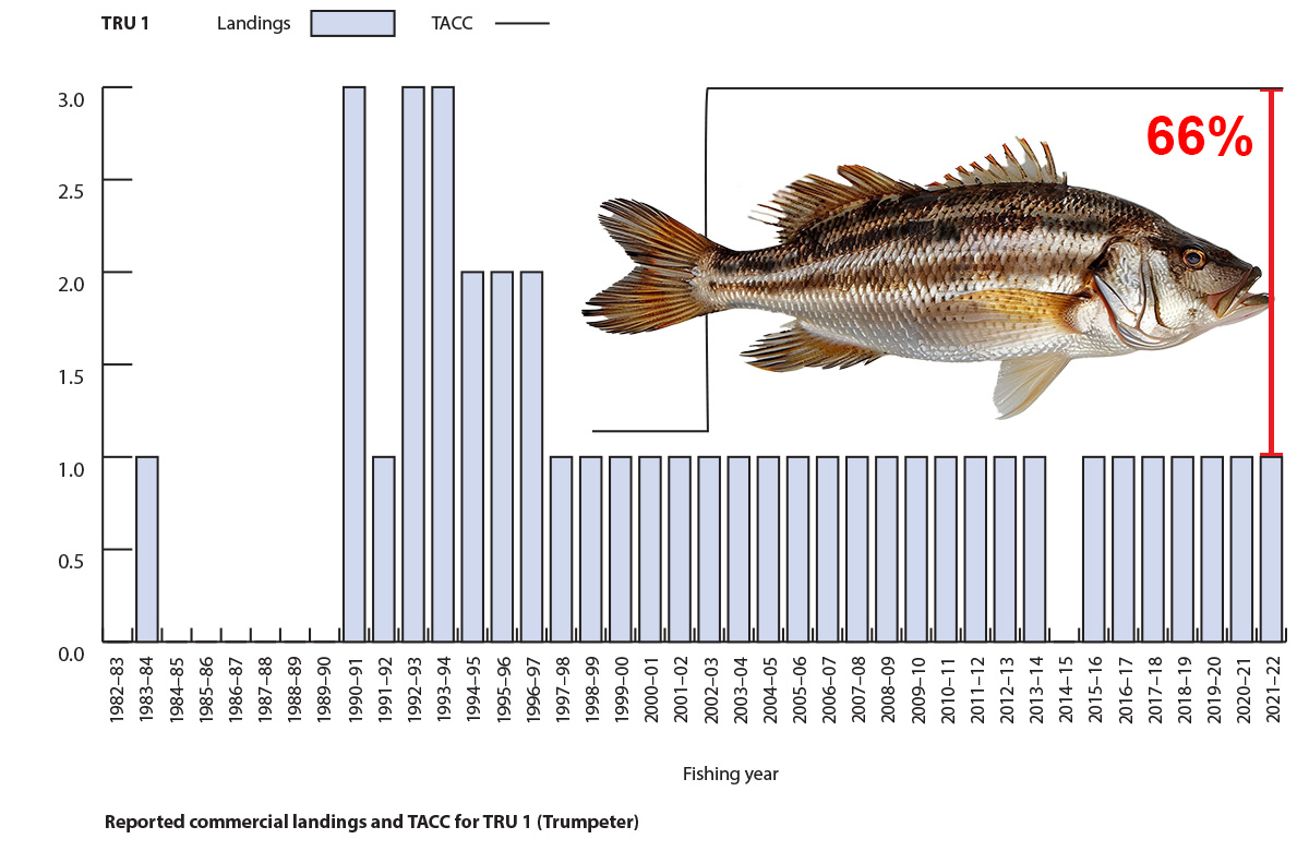
In New Zealand, we have 75 fish populations that are supposed to be managed sustainably. The main way we do this is by setting limits on how many fish can be caught, known as the Total Allowable Catch (TAC). We don’t keep regular track of the fish caught by recreational and cultural fishers. The only annual numbers are for commercial fishing, which has a limit called the Total Allowable Commercial Catch (TACC).
What’s puzzling is that for many fish populations, the TACC is set way higher than what’s actually being caught, and it’s been like that for years without any change. To me, this means these fish aren’t really being managed at all. Of the 75 in Aotearoa there are 16 fish populations in the Gulf that stand out as ‘unmanaged’ due to their TACC being significantly higher than the actual catches.
I had high hopes for the new Fisheries Management Plan for the Gulf, thinking it might sort out these unmanaged populations. I tried to get some answers by writing to the minister, and when that didn’t work, I filed an Official Information Act request. The reply came from Simon Lawrence at Fisheries New Zealand, but it wasn’t what I hoped for. They’re only planning to review four out of the 16 unmanaged populations this year – Flatfish, Rig, Blue cod, and Red cod. That leaves Pipi, Horse mussel, Paddle crab, Anchovy, Sprat, Pilchard, Jack mackerel, Pōrae, Leatherjacket, Trumpeter, Longfin eel and Spiny dogfish unmanaged. Four of these fish are at the bottom of the food web and are critical for the Gulf ecosystem function. Horse mussels are endemic (found only in New Zealand) and aggregations dense enough to be called beds are now extinct in the Gulf, Longfin eel are also endemic and going extinct.
So here we are, with a fisheries plan that talks a big game about moving towards an ‘ecosystem-based fisheries management‘ approach, but we’re not even effectively managing individual fish populations.


Submissions on the Hauraki Gulf / Tīkapa Moana Marine Protection Bill began to come online here on the 17th of January 2024. There are about 6,540 submissions so far, some have supplementary material. I have been playing with ChatGPT to write Python code to download and categorise the submissions and supplementary material.
I downloaded 7,586 PDFs. It looks like at least 70% of the submissions came from here or have similar concerns as 5,518 PDFs include one of these words / terms ” racist”, ” all people of New Zealand”, ” ancestral”, ” all New Zealanders”, ” race”, ” racism”, ” racial”, ” remove acknowledgment of customary rights”, ” customary rights should not exist”, ” oppose the customary fishing rights”, ” 1 set of rules”, ” one set of rules”, ” one law for all”, ” all people”, ” one people”, ” people equally”, ” apply to everyone”, ” skin colour”, ” discrimination”, ” apartheid”, ” separatist”, ” all citizens”, ” for all to enjoy”, ” all the people”, ” all people”, ” treated differently”, ” select group to fish”, ” one law”, ” exception for any group”, ” any one group”, ” regardless of ancestry”, ” same rights” or ” divide the people”.
Note that nearly all these submissions support the protection measures in the bill, but object to customary rights. The number of submissions appears to be increasing daily as they are processed by parliamentary staff.


