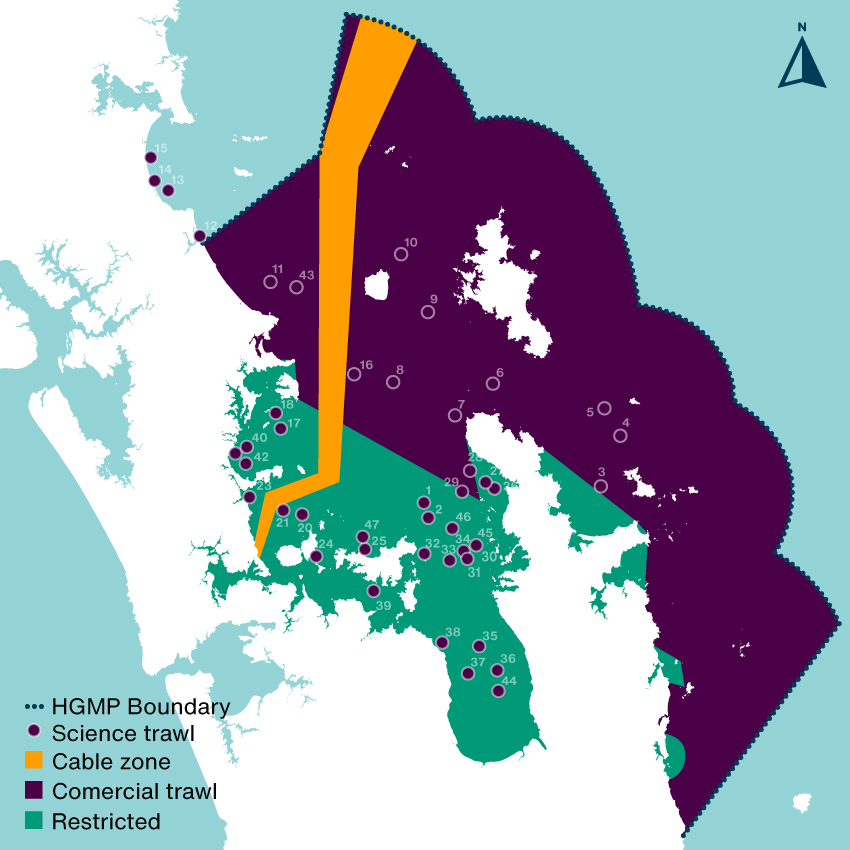
The tipa /scallop population in the Hauraki Gulf Marine Park (HGMP) is on the verge of collapse due to mismanagement by Fisheries New Zealand (FNZ). The current population is one fifth of what it was in 2012 (when they last surveyed the beds). Huge cuts are needed to save the population, most of us will experience the loss in the supermarket or the boat ramp. Here are the things they did wrong (many by their own admission).
FNZ allowed fishing methods that destroy habitat. Bottom impact fishing is irresponsible because it destroys the habitats of target species. When you kill the animal and its home a new animal is less likely to be there the second time you go hunting there. “Dredge fishing is known to have negative impacts on scallop growth, populations and the habitat that supports them” – FNZ 2021. Juvenile scallops thrown back overboard by dredge fishers (bycatch) also have a high mortality rate.
FNZ relied on self regulation. Instead of doing tipa bed surveys they relied on:
Industry self-regulation which hid declines at individual beds (the scheme is called voluntary Catch Per Unit Effort). The average catch limit for the last decade was more than double what was actually landed.
Estimates of recreational catch based on boat ramp inspections. Commercial fishing is not the only problem here, 3/4 recreational only fished beds have collapsed.
Cameras on commercial boats (which can match catch with location) and mandatory recreational catch reporting would enable finer scale regulation and stop this happening to other fish populations.
FNZ didn’t do any spatial planing. They set no areas aside as nurseries for juvenile shellfish. “It would be logical to close some scallop beds and create passive restoration (broodstock areas) to increase the fishery yield” – Dr Mark Morrison, Shellfish Restoration Co-ordination Group, December 2021. FNZ even let bottom trawlers drag their nets over tipa beds damaging both adults and juveniles and leaving them vulnerable to predation and disease. A bed that was discovered in 2011 (Hauraki bed) was fished to collapse by 2014. This bed may well have been the nursery that propped up the already declining population. FNZ (and other governing bodies) hand picked ideas from the only integrated management plan devised for the Gulf (Sea Change 2017) which planned to phase out bottom impact fishing and addressed other impacts like sediment.
FNZ didn’t take a precautionary approach. FNZ should not have to rely on iwi calling a rāhui to stop a population collapsing. No one is paying iwi to sustainably manage fisheries. The two rāhui approved under section 186A of the fisheries act were already too late to save the population but they should have been actioned much faster. Variability in the tipa population trends gave FNZ gamblers confidence and they played the fishery like a slot machine.
You can read the report that recommends closing the fishery here. I will be supporting a full closure and recommending a discontinuation of the four irresponsible behaviours. I hope that all the tipa beds recover from the closure but it’s likely many of them will not. We have recently seen this in SCA7 Golden Bay, SCA7 Tasman Bay where the FNZ collapsed the fishery, and in three individual beds (Ponui-Wilsons, Shoe-Slipper, Barrier & Kawau) in the SCA CS fishery (HGMP). Enabling the long-term damage of a habitat forming species is not just fisheries collapse or functional extinction – it’s ecocide.
Note this paper recommends eliminating bottom contact fishing is the most effective intervention to rebuild a depleted scallop populations in New Zealand
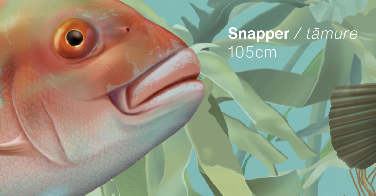
The most barbaric way to answer this question would be to drag a giant net around and count what you kill but you’re not allowed to do that in the inner Gulf where trawling is restricted… unless you have a research permit from Fisheries New Zealand (FNZ). Despite calls to stop bottom trawling in the Hauraki Gulf Marine Park (HGMP) (Sea Change 2017 & Hauraki Gulf Forum 2021) FNZ have started doing these trawls regularly, they justify the trawls are required to gather information on the Tāmure / Snapper population. They haven’t done research trawls like this since the Hauraki Gulf Marine Park Act came into effect in the year 2000 (NIWA 2019). In areas where trawling is restricted (c25% of the HGMP), the study was like bulldozing a regenerating forest to count the birds. A disgraceful act on private land let alone a national park.
How much seafloor was scraped?
The nets are massive, wider than a rugby field. FNZ were just interested in killing demersal fish (goundfish), they dragged theses massive nets along the seafloor smashing down anything that lives there and creating giant sediment plumes that contribute to climate change. In areas that have been closed to trawling for decades there are patches of horse mussel beds, sponge gardens and tubeworm mounds and other habitats regenerating after decades of abuse from heavy machinery. You can read about them in the report (NZFAR 2021) where they are described as ‘foul’ a horrible word which suggests there is something ugly about these beautiful benthic epifauna that are working hard (day and night) to clean up our pollution (they are nearly all filter feeding animals). In defense of FNZ they did try and avoid areas with a lot of immobile sea life but they failed so badly that they had to stop trawling on several occasions, this shows that a) the seafloor is recovering and b) echosound is no good for measuring trawling impact on benthic life.
Although the percent of trawled seafloor was small (less than 1% of the study area) the areas bottom trawled were huge:
39 rugby fields between Shakespear Regional Park and Rangitoto Island
Stratum 1386
54 rugby fields of the inner Firth of Thames
Stratum 1887
68 rugby fields of the mid Firth of Thames
Stratum 1268
88 rugby fields in a west-east band North of Waiheke Island
Stratum 2229
59 rugby fields around the western side of Waiheke Island
Stratum 1149
41 rugby fields north of Whangaparāoa Peninsula
Stratum 1284
40 rugby fields northwest Coromandel
Stratum 9292
60 rugby fields south of the line dividing the inner gulf
Stratum 1219
59 rugby fields from Bream Bay to Mangawhai
Stratum 1449
49 rugby fields between Aotea / Great Barrier Island and Ahuahu / Great Mercury Island
Stratum COLV
77 rugby fields north of the line dividing the inner gulf
Stratum LITB
A total of 615 rugby fields, 381 of those fields had not been physically impacted by trawling for decades. The trawls were about 1/10th as long as a commercial trawl which may impact 1–10 km2 (MacDiarmid 2012). This is largely due to the horrific sediment plumes they create, especially on mud which most of the trawls in restricted areas were. This means the total trawl distance of 53.35km could have impacted up to 40km2 (6,349 rugby fields) of seafloor – choking animals and smothering plants.
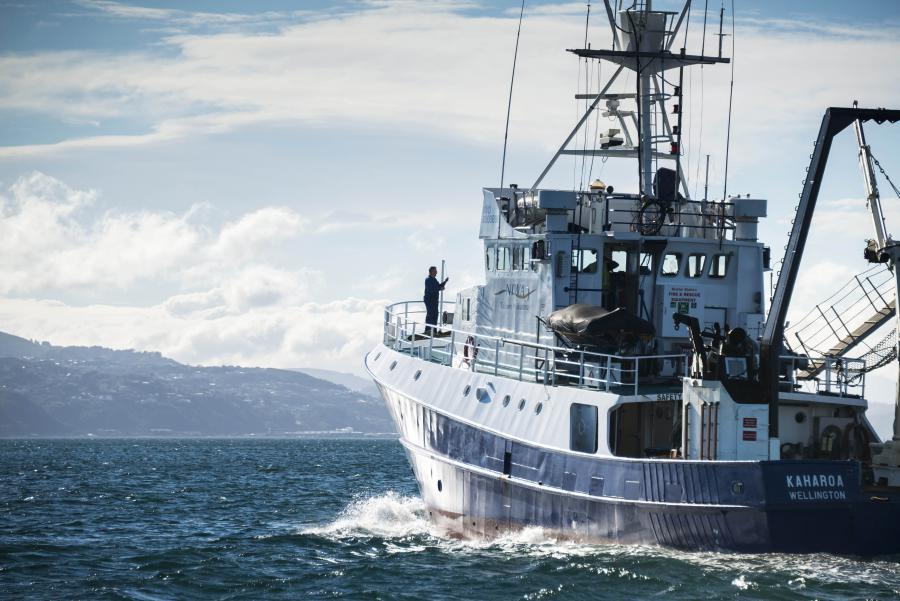
The research trawler Kaharoa. Photo by Dave Allen (NIWA).
So where were all the fish?
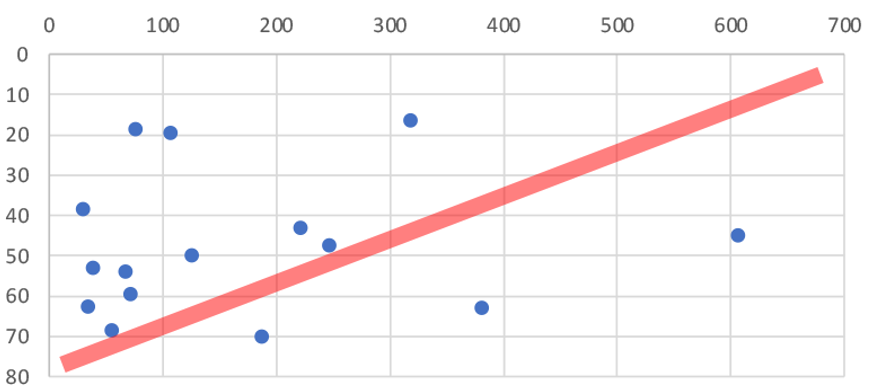
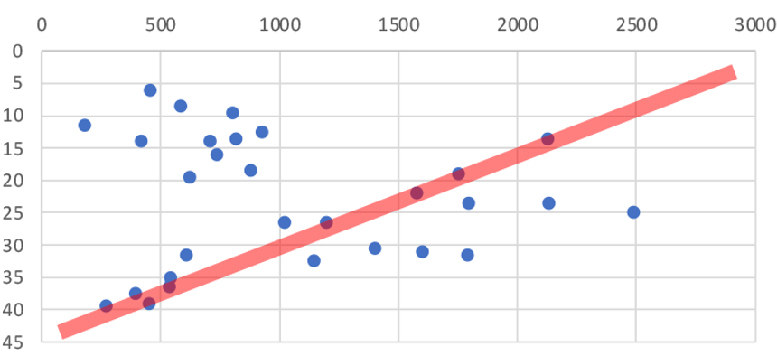
The average catch weight per trawling station in restricted areas was 500% higher than areas where bottom trawling is not restricted (1,033kgs vs only 171kgs). That’s a huge difference, the commercial fishers pulling up the nets must have been blown away with the haul! There was no significant difference in the size of the trawls but there was a big difference in depth. Trawls in trawling restricted areas averaged about half the depth (23m) of those in regularly trawled areas (47m). So are the fish benefiting more from trawling restrictions or depth?
Figure 1. Catch weight per station by depth in trawled areas. The red line predicts catch weight going down in deeper areas.Figure 2. Catch weight per station by depth in areas where trawling is restricted. The red line predicts catch weight going down in deeper areas.
As you can see from Figure 1 & 2 there is no correlation between depth and catch weight (red line vs data). There could be many other factors involved (FNZ seemed to deliberately avoid trawling on sand in the inner Gulf so we can not directly compare substrates), but the 500% increase in catch weight in areas protected from trawling shows that protecting the seafloor from bottom trawling dramatically increases the amount of fish that live on the seafloor.
The survey is good news for recreational fishers who shouldn’t leave the inner Gulf to catch more Tāmure / Snapper. If you’re a fisher who wants to know where demersal fish are in the Gulf I recommend you read the report (NZFAR 2021). If you want to know which trawling station got the highest catch… I’m not telling! You will have to ask FNZ, you can send them an OIA request Official.InformationAct@mpi.govt.nz why don’t you tell them to stay out of the restricted areas and stop bottom impact fishing at the same time 😀
What happened to all the fish?
The total weight of fish (mostly Tāmure / Snapper) landed was 41,759 kilograms! 80% of the dead fish was sold for $128,449.35 which seems like a lot but with Tāmure at $20-$30 per kg at the supermarket they could have made more than one million dollars selling it direct to consumers. Of the total revenue from the two years of survey approximately 73% ($93,634.47) was absorbed in operation costs of the research vessel to process the catch. The remaining balance ($34,814.88) was returned to the Ministry of Primary Industry. That means even selling the dead fish dirt cheap the surveys make a profit for the Government. The self issued scientific permit to trawl in restricted areas is more profitable than some whaling trips the Japanese government justifies as science.
What else did they haul up?
I was surprised to see invasive species like Mediterranean fanworm (Sabella spallanzanii) turning up in the catch. They are very skinny and should fly through the nets. There must have been very dense beds in places. It was disappointing to hear from my Official Information Act request that Biosecurity New Zealand was not informed of which stations had high numbers of the Unwanted Organism. The lack of interagency communication (even with MPI) sucks but the double standard is worse. When restoring the seafloor from fishing damage the Mussel Reef Restoration Trust must notify an MPI technical officer if it accidentally releases an Unwanted Organism (a legal requirement of moving Unwanted Organisms under the Biosecurity Act 1993). Bottom trawlers however can move them around the Gulf with no regard to Biosecurity. This shows how Biosecurity NZ favours industry over community groups.
Will they do it again?
The surveys continue despite FNZ no longer having a public license to bottom trawl the HGMP. There is 84% public opposition to fishing methods that impact the seafloor (Hauraki Gulf Forum 2021). Most fisheries scientists take samples 100’s of times smaller or use baited underwater video cameras to count and measure fish. FNZ definitely don’t have a social license to trawl in restricted areas but they are ploughing on. Because I make a living doing science communication its not in my interests to criticise the research survey but I had to because I think what they are doing is wrong.
Notes
I included trawl stations in areas where Danish seining is allowed and trawling is restricted in the restricted totals. The three stations had an average catch weight that lowered the average restricted catch weight and increased the average catch depth.
References
Sea Change 2017. Sea Change – Tai Timu Tai Pari Marine Spatial Plan. Hauraki Gulf Forum, Ministry for Primary Industries, Department of Conservation, Waikato Regional Council, Auckland Council. 2017.
MacDiarmid 2012. Assessment of anthropogenic threats to New Zealand marine habitats. A. MacDiarmid. New Zealand Aquatic Environment and Biodiversity Report No. 93 2012
I have illustrated most of the mobile animals you might see on a protected shallow reef in North Eastern New Zealand. It’s available as a canvas print, framed art print, metal print, photographic print and poster on Redbubble.com
If you buy one please send me a photo so I can see how it looks, below is the large poster in semi gloss. I was really pleased with the result and will stick it on the wall by my dive gear.
Here are a few closeups.
All my profits from the sale of the work will go toward marine protection initiatives in New Zealand.
I have been helping out Auckland Zoo and the Department of Conservation with important conservation work, and last year Auckland Zoo had an unusual request.
“Can you make flamingo eggs? Our flock of Greater flamingos have a tendency to kick their eggs into the water, so we give them a ‘dummy’ egg whilst we place their precious egg safely in an incubator.”
In the past I have only assisted with endemic or threatened species so I was a little hesitant, that was until I went on a short tour of the Zoo’s flamingo habitat and met the birds. I learnt that in the wild, flamingo habitat is indeed threatened, and I was captivated by these elegant, head-high birds. One of the young females named ‘Otis’ wandered over and gave me a friendly chest bump. Immediately smitten, I have made 21 eggs for the flock. There were two technical challenges:
The eggs have an unusually rough surface, I started off covering the smooth 3D printed models with epoxy but this quickly became laborious. Instead, I sculpted a texture on the 3D model and was impressed how well it printed.
I had to get the weight just right. I achieved this by filling the eggs with sterilised sand, then water to make sure pressure changes from expanding and contracting air bubbles would not stress the resin shells.
One of the eggs has been successfully tested and I hope Otis & co will be happier spending more time sitting on eggs.
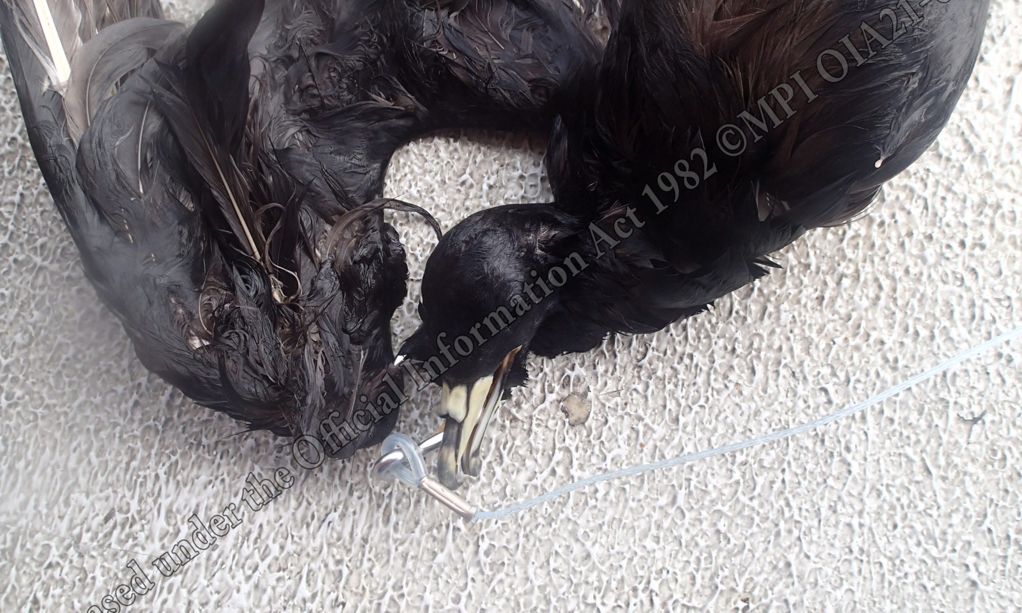
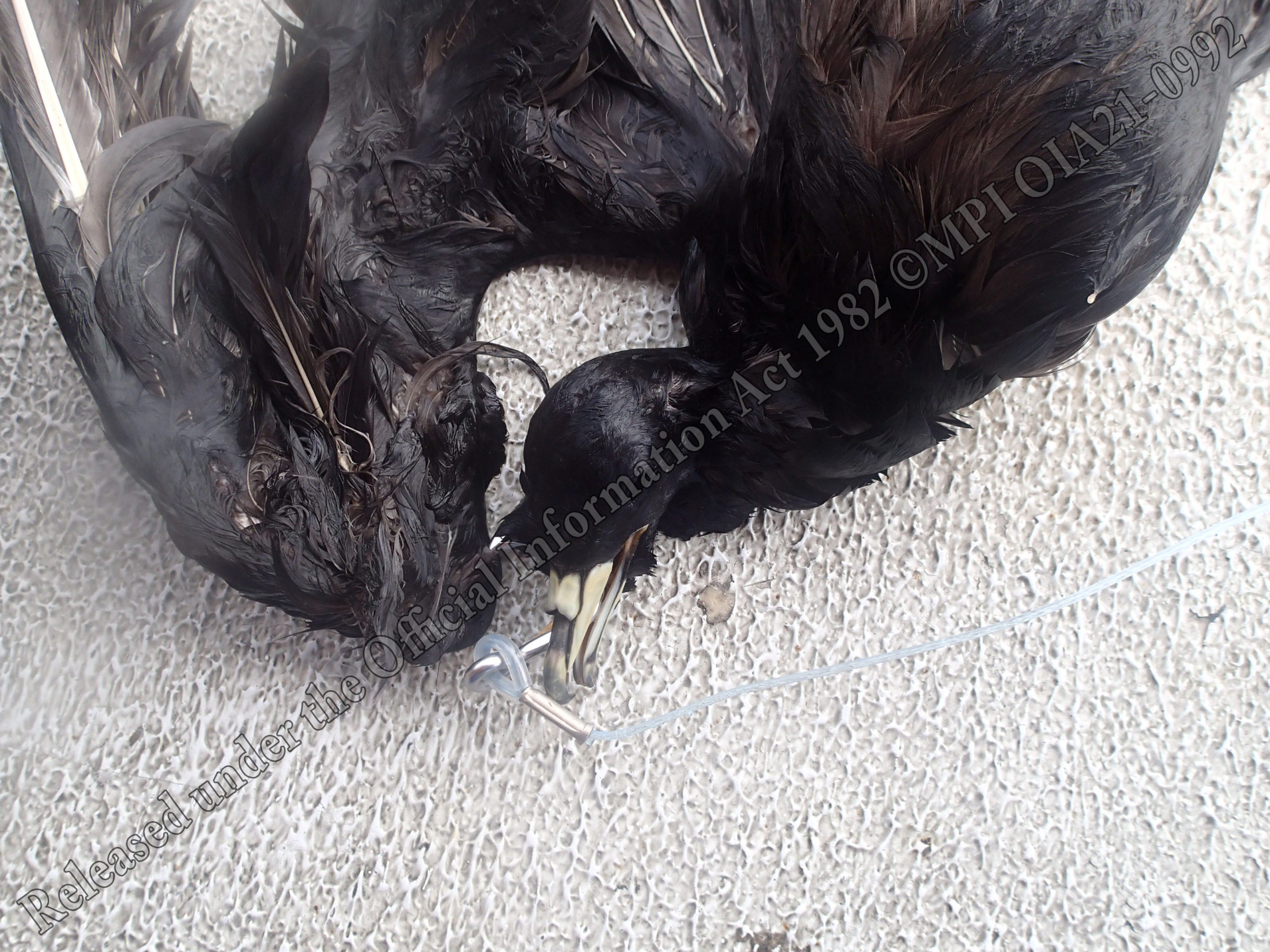
I sent in another Official Information Act request for images of the reported seabirds caught by commercial fishing in the wider Hauraki Gulf region. It was nice to see that three out of sixteen did not die (in this instance they are usually not photographed). Here are some photos of the dead birds. They are rather miserable to look at, but its great Fisheries New Zealand has shared high resolution images.
I checked to see if any of the records were reported by fishing boats without observers – the answer was no. This means there are a lot more endangered birds dying that no one knows about.
Let’s start recording deaths, here is a map of how many seal pups have died so far in 2021. Please help by recording any seal observations on iNaturalist, or you can email me photos shaun@stet.co.nz.
Wouldn’t it be great if the Hauraki Gulf Marine Park was a place kekeno / fur seal pups could come and thrive in.
Update 6 Oct 2021. The Department of Conservation have offered to help with identification. Here are some tips for taking photos: Please take the main photo straight down from above, with a foot for scale, and possibly some close ups of head and flippers (flipper length is often what we use to tell a pup of the year from a yearling).
Like many Aucklanders I am sick of having my beach closed to swimming due to ‘stormwater overflows’ which is a nice way of saying ‘human poo has gone into the ocean’. Here is a graphic I made for the 2020 State of our Gulf report to explain how it happens.
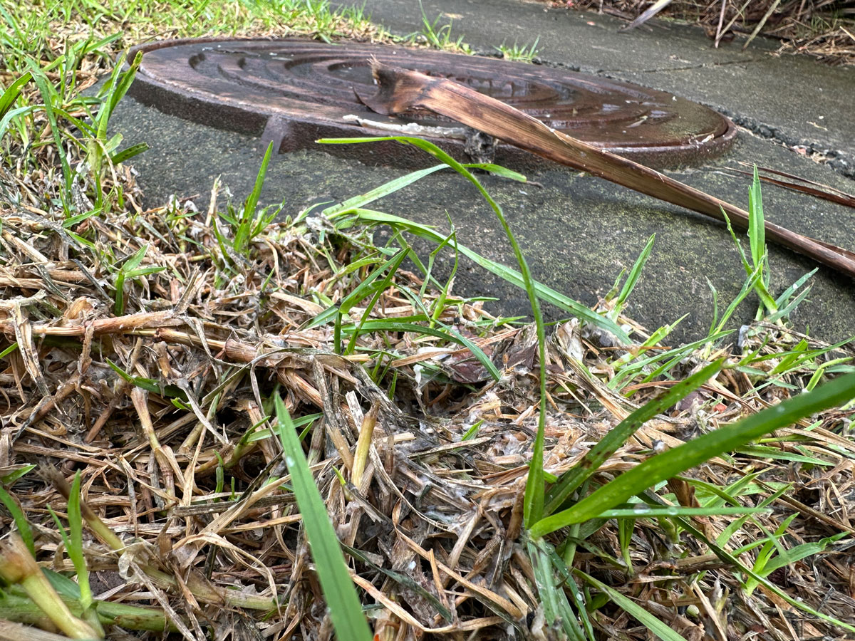
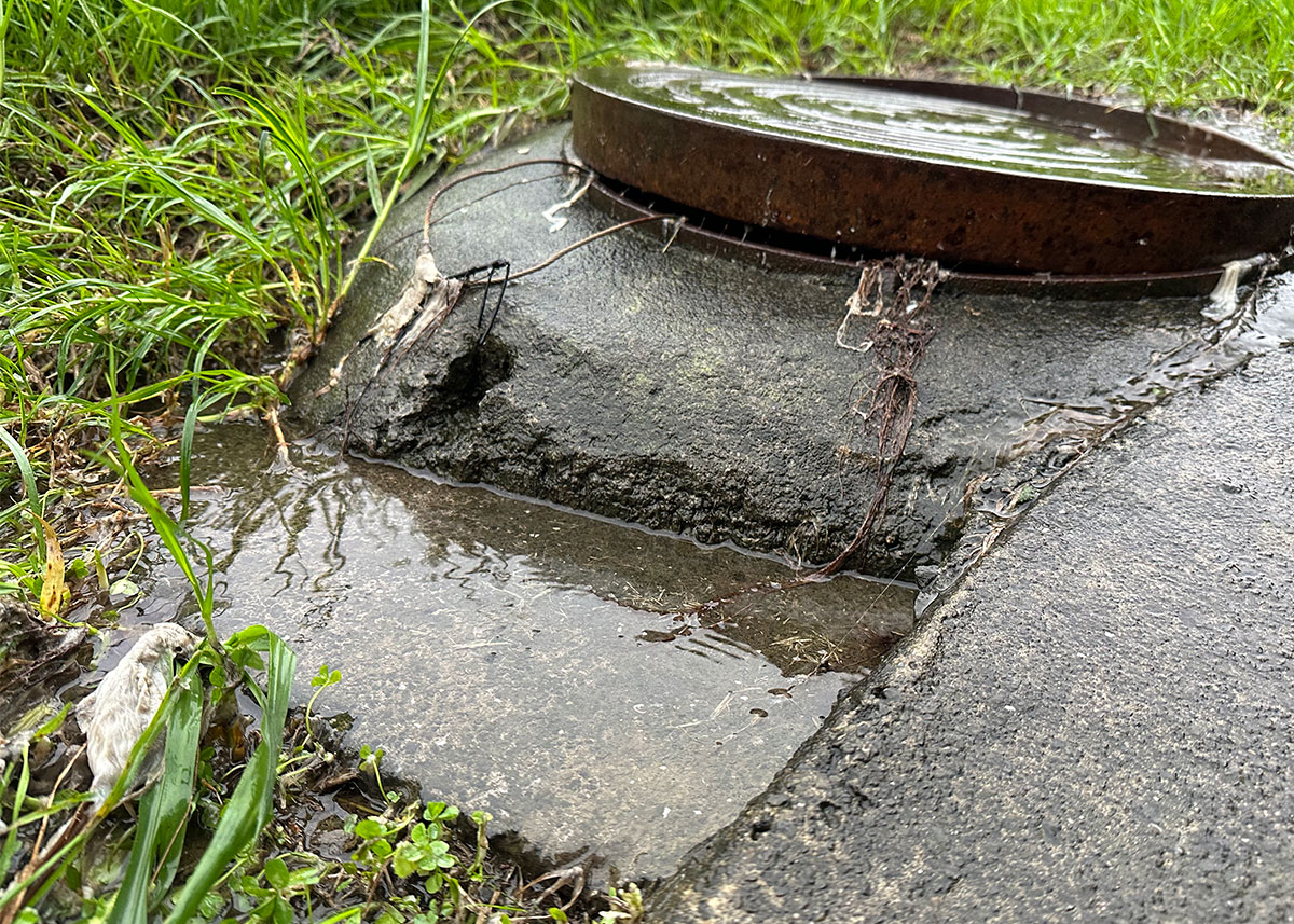
Yesterday I found a manhole that had overflowed next to the Tāmaki Estuary with fragments of toilet tissue all over the public pathway. I logged the fault with Watercare (reference number of this is SR 4943060) and a contractor visited the site after dark. The verbal report I received to the public health hazard was very cavalier, I was told it would not happen again. I have asked for a written report.
UPDATE 25 Sept 2021: The Chair of the Tāmaki Estuary Protection Society has sent me this map which shows that Watercare do not consider the manhole a ‘significant overflow point’ for sewerage during heavy rain.
UPDATE 26 Sept 2021: Watercare have been very responsive, they would not give me a written report but confirmed that in the short-term there is nothing they can do to stop raw sewage from overflowing into the nature reserve / public path after heavy rain events. They said biohazards in Auckland were ‘a common problem during heavy rain’. I am appalled at their low hygiene standards. We will monitor the manhole and Watercare have offered to escalate the issue if it is ongoing.
UPDATE 28 Sept 2021: After another complaint Watercare have offered to fill holes and check for blockages Ref SR 4960390.
UPDATE 28 Oct 2021: The Watercare officer lied to me. New reference number: WEB1065983. Fault reference number SR 5172998.
A nearby manhole next to a children’s playground that also overflowed.
UPDATE 30 Oct 2021: I received a text message saying the fault has been resolved. I called to see what has been done. They explained they have added lime to to disinfect the grass, there is no blockage, and that it will probably happen again next time it rains. I can see why people dont report sewage overflows when nothing is done to fix them.
Auckland City has the terrible hygiene standards.
UPDATE 4 Nov 2021: The issue has been escalated by Councillor Josephine Bartley (it’s a good idea to loop your Councillor into difficult conversations with council staff). They have identified three actions which might address the issue. I have asked them to tell me:
When the pipe is relined
When the first flush event to clear blockages occurs
When any of the infrastructure upgrades come online
I have also asked that Council not approve any consents that would increase stormwater or wastewater pressure on the failing infrastructure until the issue is resolved.
UPDATE 21 Mar 2022: Still failing. It’s interesting how you can smell that the manholes have popped before you see them.
North of the footbridge near Fernwood Place PlaygroundSouth of the footbridge near Fernwood Place PlaygroundThe reserve between Silverton Ave and the Estuary
UPDATE 5 April 2022: Watercare have replied with a list of actions.
Pipeline Reline
The pipe reline is currently under review, as more investigation is required to help us pull together a package of work in Wai O Taiki Bay to reduce infiltration of stormwater into the wastewater system (through pipe joints, cracks in manholes etc). This will take some time to put together and then implement (potentially a year).
Flushing event
We have put this part of the network on a routine flushing programme which will allow the pipe to operate at maximum flow (by flushing out silts regularly as they build up fast due to low pipe grade). Last year showed a lot of silts in this line, which we have since cleared.
Other works
We have done some small improvements to downstream manholes to allow flow to pass through easier.
Project works
The work on Taniwha St is currently in progress and will all go live once our new wastewater pump station is commissioned. This is still several months away and most likely to be at the end of the year.
They are also looking at installing a sensor inside the manhole and wrote a very polite thank you email. I repeated my request to not increase pressure on the system and will continue to monitor these manholes.
Update 12 July 2022 (No change)
Fernwood Place PlaygroundWai O Taiki Bay Nature ReserveTreated with lime the next day
Update 27 January 2023 (No change)
I was not able to get down to the manholes during the last two rain events.
This attempt to glue the manhole down has failed.No smell this time, but toilet paper visible at both manholes.
Update 1 May 2023 (No change)
I’m not reporting this event. Large areas of Auckland Councils stormwater network failed in recent storms and they will have bigger priorities for the near future.
Update 9 May 2023 (No change)
Interestingly the manhole next to this one also popped for the first time.Yuck
Update 21 Jul 2023 (No change)
Leaking toilet paper in smaller rain eventsLooks like Council have not restricted development and more intensive housing will put more strain on the systemPolystyrene escaping the demolition site
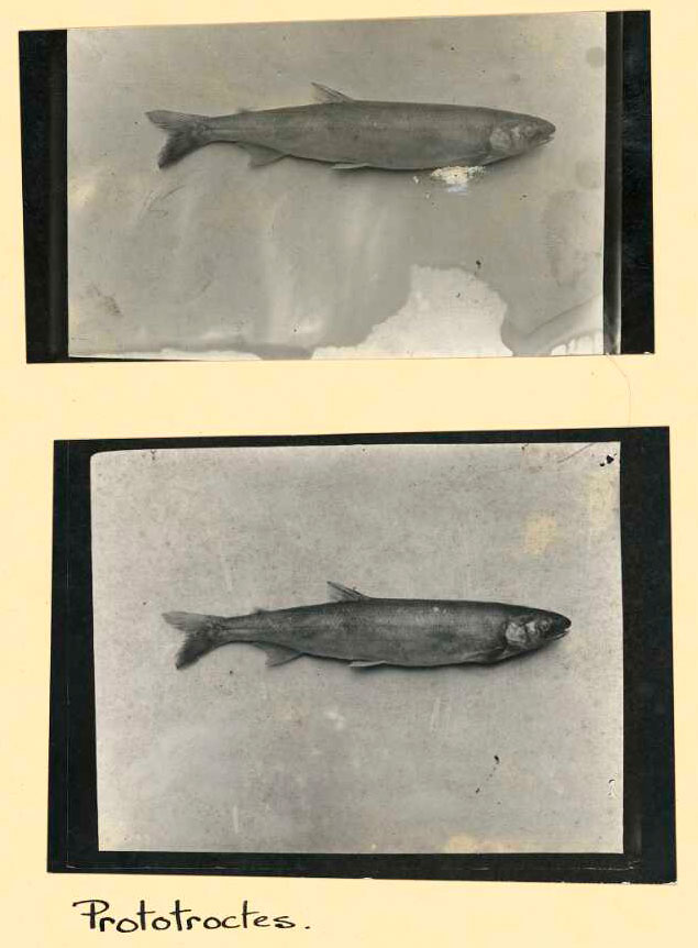
We have many freshwater fish that are going extinct but only one is protected (meaning you can’t kill it without a permit). Unfortunately this fish the Upokororo / New Zealand Grayling went extinct about 100 years ago.
Many illustrators have attempted to recreate what the Upokororo looked like, some have seen the fish but not many have seen this photo taken in 1922.
My illustration of the Upokororo is based on these two photographs, I referred to historic illustrations, photos of the related Australian grayling and some very colourful written records for colour information.
The story of the Upokororo is a powerful reminder that we need to carefully manage fish populations, especially source / sink dynamics.


