Over the summer I read Lucy Baragwanath’s copy of Seacoast in the seventies – the future of the New Zealand shoreline by John Morton and friends. It’s a fascinating insight into the pressures on Auckland’s coastline in the early 1970’s. The book mentions an upcoming study on the ecology of the Auckland Harbour. Lucy and I were able to track it down and Paul Kennedy kindly let me borrow his copy.
The Waitemata Harbour Study 1973 by M. F. Larcombe is an incredible record of the intertidal zone but it’s very hard to read because, not only are there a lot of scientific names many of them have changed over time. I used records from iNaturalist.nz to make a visual alphabetic key with updated names to make it easier to read. For some reason not a single scientific study on Google scholar references the study. I hope that changes.
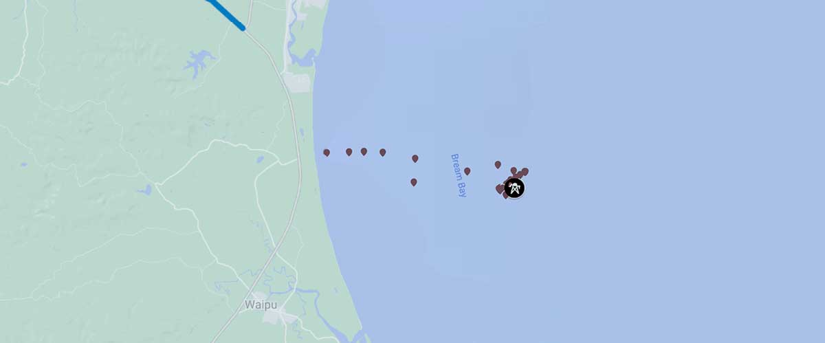
When I saw the proposed new Fast-track sand mine in Bream Bay placed on a map by Marc Daalder I thought I would have a look at the site.
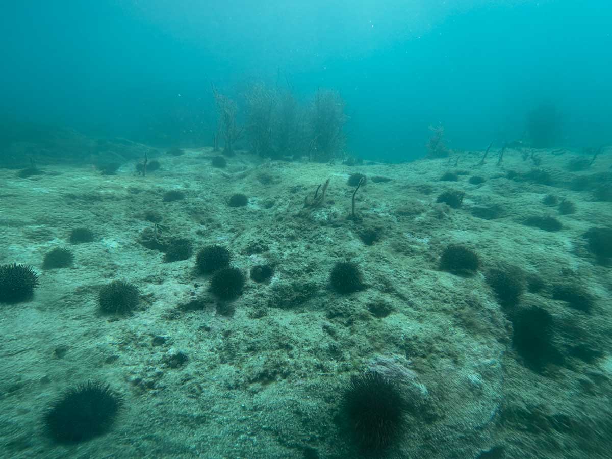
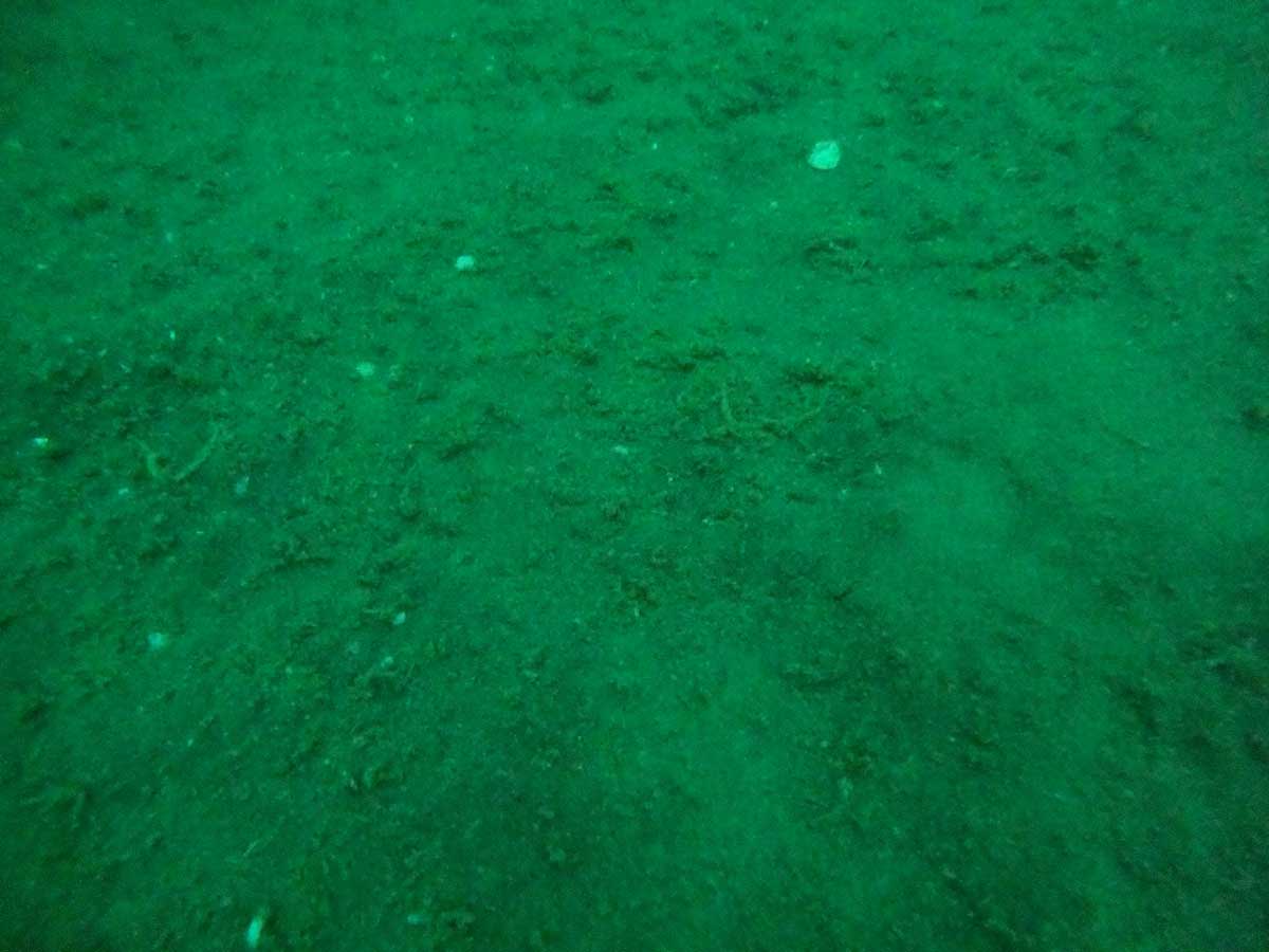
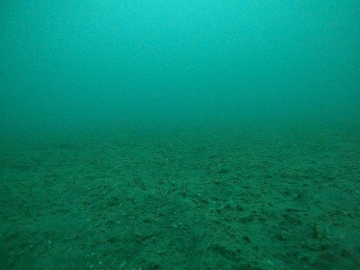
I launched my kayak from Uretiti Beach and paddled 6.5 km to the site. On the way I paused six times to drop a weighted GoPro on timelapse from a dive line to photograph the seafloor. I then paddled South West of the mining site and took 12 more photos in a 1km North East transect.
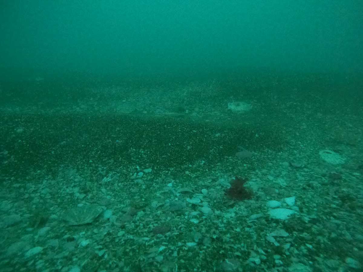
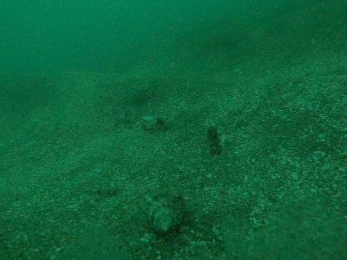
I was not expecting to see much benthic biodiversity as the area is frequently trawled. However I was very pleased to find extensive non-calcareous tubeworm fields (Spionidae – I think) in half the photos, mostly at the north-eastern end of the transect. The filter-feeding tubeworms are a good sign the seafloor is stable and able to support even more complex biogenic habitats if trawling pressure was removed. (Sand mining directly and indirectly impacts biogenic habits, these complex 3D structures made by life on the seafloor are easily buried by unstable substrate.) The tubeworm fields are also associated with tipa / scallops. I was only clearly able to identify one live tipa in the 12 photos but tipa shells were a common feature of the area.
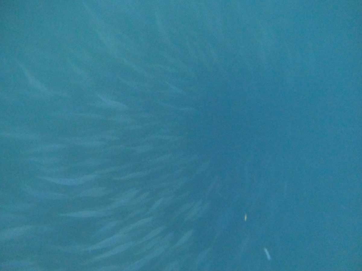
It was a quiet afternoon on the surface with no workups seen, however single tākapu / gannets were working the area, I counted five kororā / little penguin on the way to the site and a tight ball of forage fish.
tipa shellslarge ostrich foot snaillive tipatight ball of forage fishtubeworm fieldtubeworm field
I made these graphics for Auckland Council to show people how to make healthier and more resilient waterways. It’s awesome to see informed leadership on attitudes to rural and urban land use.
Artificial reefs have significant potential to boost fish populations, even surpassing pre-fished levels or what is possible in marine reserves. However they have a checkered history overseas, with many reefs:
Failing to restore native biodiversity to levels of those of conserved natural reefs (Bracho-Villavicencio et al. 2023).
Creating hard surfaces which are favoured by invasive species (these species often travel to new areas on hard structures) (Gauff et al. 2023).
Created as a convenient way to dispose of something which pollutes the marine environment (E.g. UnderwaterTimes.com 2006). They can also attract polluting activities (Zhang et al. 2019).
When considering building an artificial reef, it is crucial to determine whether it will provide additional habitat to support reef communities or merely function as a Fish Aggregation Device (FAD). Like artificial reefs, FADs are man-made structures which are attract fish to a specific area by providing habitat and shelter for marine life. The problem with FADs is that they decrease local fish populations by concentrating them in one area where they are easily targeted by fishers (Cabral et al. 2014) as illustrated below.
To define the size of the habitat required to avoid FAD functionality, you could base it on the home range of each fish species you want to increase. For example:
The most studied fish in the Hauraki Gulf is the tāmure / snapper, which show high site fidelity to reef habitats. Tāmure in deep soft sediment habitats are quite mobile, with a median distance of 19 km, and some movements up to 400 km. In contrast tāmure in shallow rocky reef habitats have restricted movements, with a median distance of 0.7 km (Parsons et al. 2011). You can see this in small marine reserves with shallow rock reefs, such as the 5 km² Cape Rodney – Okakari Point Marine Reserve (Goat Island), which effectively increase the size and abundance of this species. Additionally, tāmure around mussel farms have been found to be healthier than those in surrounding soft sediment habitats (Underwood 2023). The studied mussel farms were near rocky reefs and covered about eight hectares (200 x 400m).
This means fished artificial reefs should be deployed at hectare scales to avoid acting as population sinks. For tāmure, an area about the size of eight rugby fields is a considerable undertaking, but to avoid your reef functioning as a FAD for fishing, it is essential to spread your structure over a large area. If this sounds more like ‘habitat enhancement’ than an artificial reef, then perhaps that is a better way to frame your design. Of course, this consideration is unnecessary if your artificial reef is not fished.
REFERNCES
Bracho-Villavicencio et al., 2023 https://doi.org/10.3390/environments10070121 A Review of the State of the Art and a Meta-Analysis of Its Effectiveness for the Restoration of Marine Ecosystems. Environments.
Gauff et al., 2023 https://doi.org/10.1016/j.jembe.2023.151882 Unexpected biotic homogenization masks the effect of a pollution gradient on local variability of community structure in a marine urban environment.
Underwood et al., 2023 https://www.aquaculturescience.org/content/dam/tnc/nature/en/documents/aquaculture/AquacultureHabitatComparativeReport.pdf Habitat value of green-lipped mussel farms for fish in northern Aotearoa New Zealand
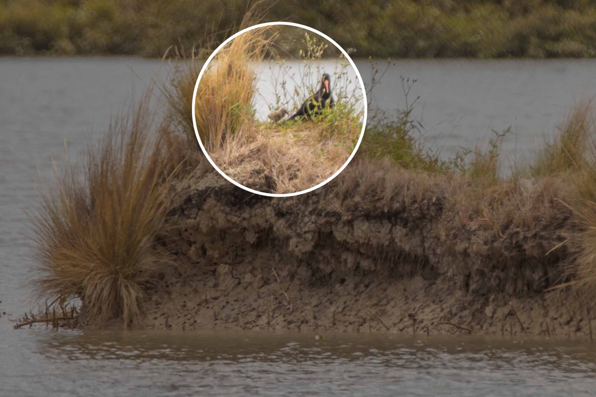
This summer Tōrea pango / Variable Oystercatcher have nested for the first time at Tahuna Torea Nature Reserve (written records began in the 1970’s). Its also the first time any bird has nested on the man-made shorebird roosts (or islands) in the lagoon. Tōrea Pango are recovering from being threatened with extinction and are one of the most endangered breeding birds in the Eastern Songbird Project area. The nearest breeding area is Motukorea / Browns Island which is a population sink for the species. The reserves name ‘torea’ does not come from this species but the South Island Pied Oystercatcher which once gathered here in great numbers.
The two egg nest was laid days after I trimmed the vegetation on Kuaka Island mid November 2023 as part of a roost restoration project. A team of local bird watchers kept a close eye on the nest. The mud in the lagoon keeps the cats out, but not the rats, the trapping team stepped up efforts and rats stopped turning up on the trail camera. One of the eggs was not fertile but the other one was and the bird watching team was thrilled when a chick hatched just in time for Christmas.
Tōrea Pango Chick on Kuaka Island. Photo by Shaun Lee.
The nest would not likely have survived a kiteboarding event in the lagoon. Thanks to the kiteboarders for volunteering to stop kiting in the lagoon at high tide. If you do see anyone kiting in the lagoon phone me 021 555 425 and I’ll have a chat to them.
Tōrea pango whanau at Cable Beacon Point. Photo by Basil Avery.
It was interesting that after nesting on Kuaka Island where I had trimmed vegetation and where a small amount of mangroves have been removed (not the majority) the parents then took the chick 400 m southeast to Cable Beacon Point. New mangrove stumps here were used by the chick to hide. I put up a sign and the bird watchers were on high alert for a few weeks until the chick fledged. The Tōrea pango whanau have stayed in the area which is a great endorsement of the reserve from our feathered friends and a huge win for our shorebird habitat restoration efforts.
The fledged Tōrea pango chick. Photo by Shaun Lee.
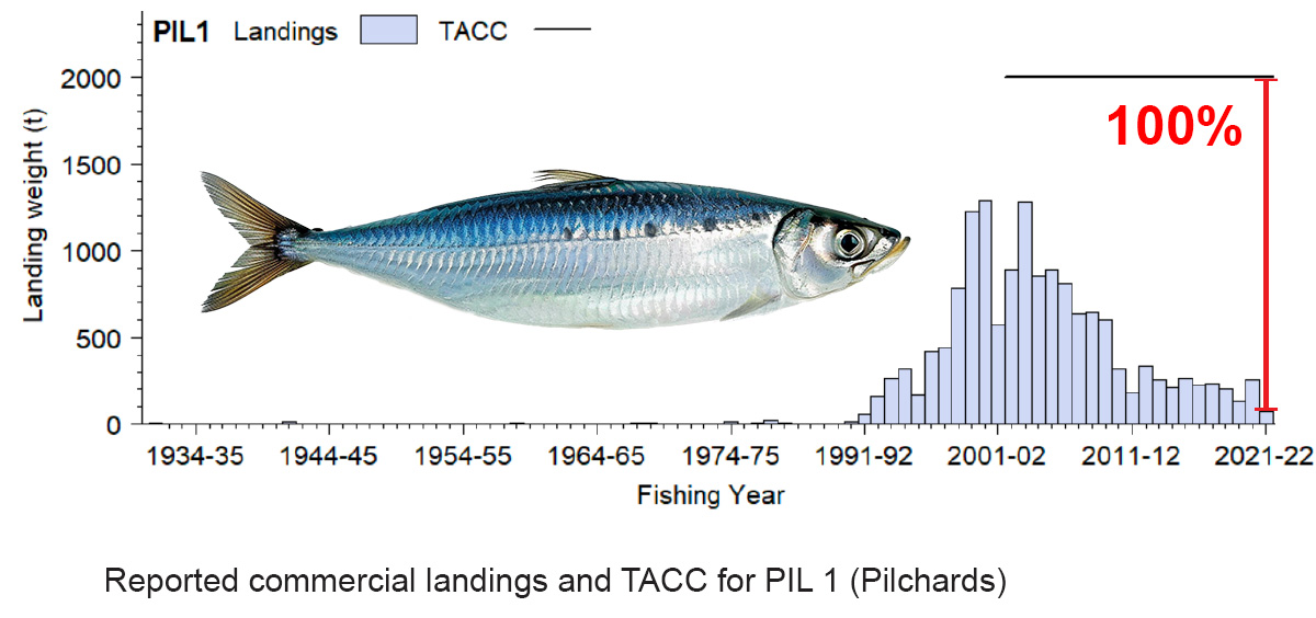
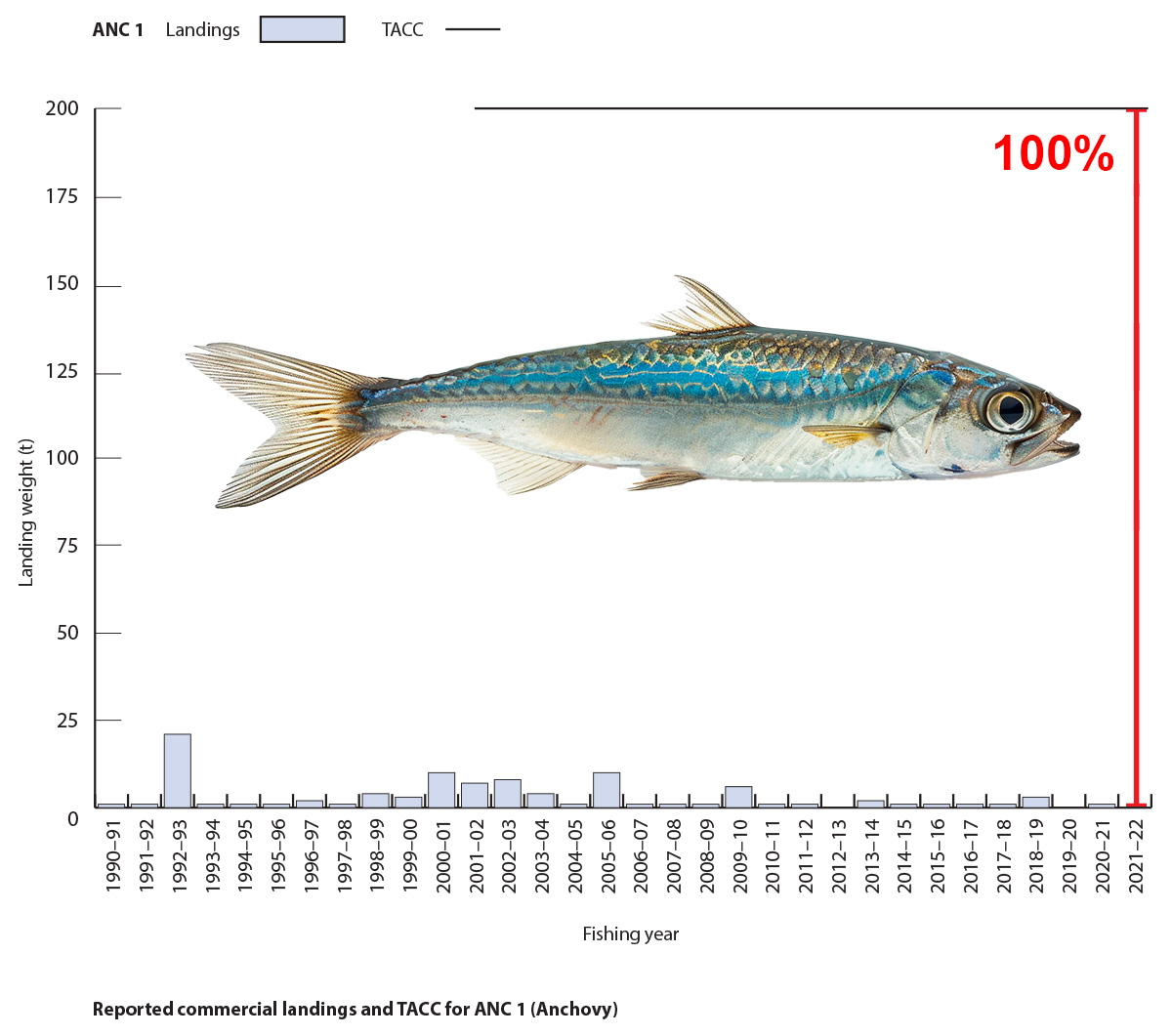
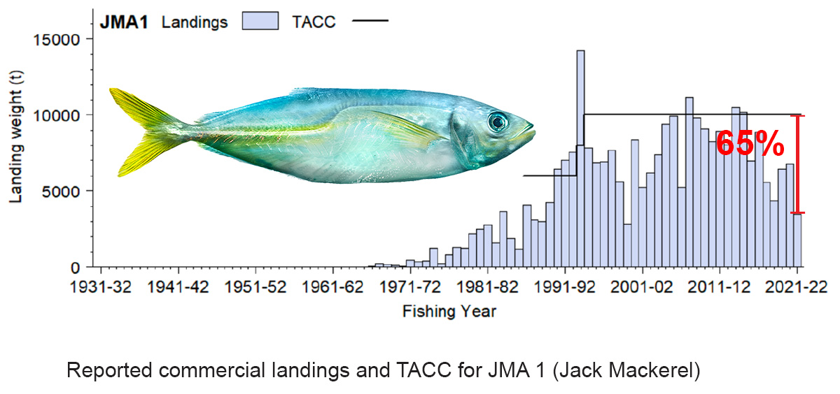
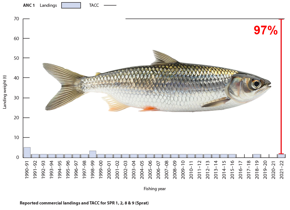
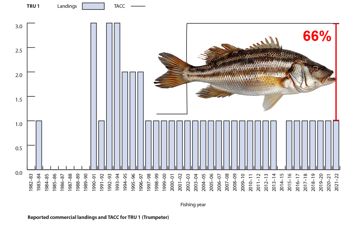
In New Zealand, we have 75 fish populations that are supposed to be managed sustainably. The main way we do this is by setting limits on how many fish can be caught, known as the Total Allowable Catch (TAC). We don’t keep regular track of the fish caught by recreational and cultural fishers. The only annual numbers are for commercial fishing, which has a limit called the Total Allowable Commercial Catch (TACC).
What’s puzzling is that for many fish populations, the TACC is set way higher than what’s actually being caught, and it’s been like that for years without any change. To me, this means these fish aren’t really being managed at all. Of the 75 in Aotearoa there are 16 fish populations in the Gulf that stand out as ‘unmanaged’ due to their TACC being significantly higher than the actual catches.
I had high hopes for the new Fisheries Management Plan for the Gulf, thinking it might sort out these unmanaged populations. I tried to get some answers by writing to the minister, and when that didn’t work, I filed an Official Information Act request. The reply came from Simon Lawrence at Fisheries New Zealand, but it wasn’t what I hoped for. They’re only planning to review four out of the 16 unmanaged populations this year – Flatfish, Rig, Blue cod, and Red cod. That leaves Pipi, Horse mussel, Paddle crab, Anchovy, Sprat, Pilchard, Jack mackerel, Pōrae, Leatherjacket, Trumpeter, Longfin eel and Spiny dogfish unmanaged. Four of these fish are at the bottom of the food web and are critical for the Gulf ecosystem function. Horse mussels are endemic (found only in New Zealand) and aggregations dense enough to be called beds are now extinct in the Gulf, Longfin eel are also endemic and going extinct.
So here we are, with a fisheries plan that talks a big game about moving towards an ‘ecosystem-based fisheries management‘ approach, but we’re not even effectively managing individual fish populations.
Environmental reports and main stream media are often critical of different aspects of the New Zealand dairy industry. Here I summarise them together in one graphic. View at higher resolution by clicking on the image below.
Graphic summary of the New Zealand’s dairy industries impacts.
References – resources for further reading on the impacts of New Zealand’s dairy industry.
Turned into junk food overseas. Nestlé is Fonterra’s largest customer. I recommend you do your own research into products which use milk powder as an ingredient and decide if they fit your definition of junk food or not.
Like many locals I regularly ask people to not walk their dog at Tahuna Torea Nature Reserve. Sometimes dog walkers push back and say they are allowed to walk their dogs on the beach or around the top of the track. To make it clear here is the wording from the Auckland Council website:
To map the “beach and foreshore areas”, I projected the boundaries perpendicular to the starting points on land, down to the low tide line. Mean Low Water Springs (MLWS) has been visually estimated.
Update March 2024
Roberta Reserve also excludes dogs on the foreshore and playground. There is an exemption for the area in the water of the stream mouth seaward side of the bridge on Roberta Reserve.


