Calculating the area of marine protection in the Hauraki Gulf Marine Park

Statistics regarding marine protection in the Hauraki Gulf Marine Park have become inconsistent since the Hauraki Gulf Marine Protection Bill came into effect in 2025. Many people are still citing protection figures from early consultation documents, which do not reflect the boundary edits made following public feedback. To determine the actual current extent, I downloaded the GPX coordinates for the newly designated areas and used GIS software to generate polygons, tracing the coastlines and excluding vegetated island landmasses to calculate the true marine area.

High Protection Area (HPA) Hectares
Te Hauturu-o-Toi / Little Barrier Island HPA 18,768
Aldermen Islands / Te Ruamahua (north) HPA 13,326
Aldermen Islands / Te Ruamahua (south) HPA 15,600
Mokohinau Islands HPA 11,886
The Noises HPA 6,049
Kawau Bay HPA 4,190
Motukawao Islands HPA 2,910
Cape Colville HPA 2,665
Slipper Island / Whakahau HPA 1,348
Pakatoa and Tarahiki / Shag Island HPA 1,273
Rangitoto and Motutapu HPA 1,058
Tiritiri Matangi HPA 826
Marine Reserves in the Gulf Hectares
Tāwharanui Marine Reserve 364
Mōtū Manawa-Pollen Island Marine Reserve 500
Te Matuku Marine Reserve 690
Cape Rodney-Okakari Point Marine Reserve 2,036
Te Whanganui-o-Hei / Cathedral Cove Marine Reserve 2,243
Proposed Hākaimangō-Matiatia Marine Reserve 2,350

Note I have excluded the Seafloor Protection Areas which are mostly meaningless.

The Hauraki Gulf Marine Park was calculated at 1,200,000 ha, but modern GIS software is giving us a figure closer to 1,400,000 ha (page 3). These numbers include the islands (~60,000 ha), so the area of ocean is about 1,340,000 ha.

We can now calculate the percent of any given marine protection area. E.g.

The Cape Rodney-Okakari Point Marine Reserve 2,036 ha is 0.152% of the 1,340,000 ha Marine Park.

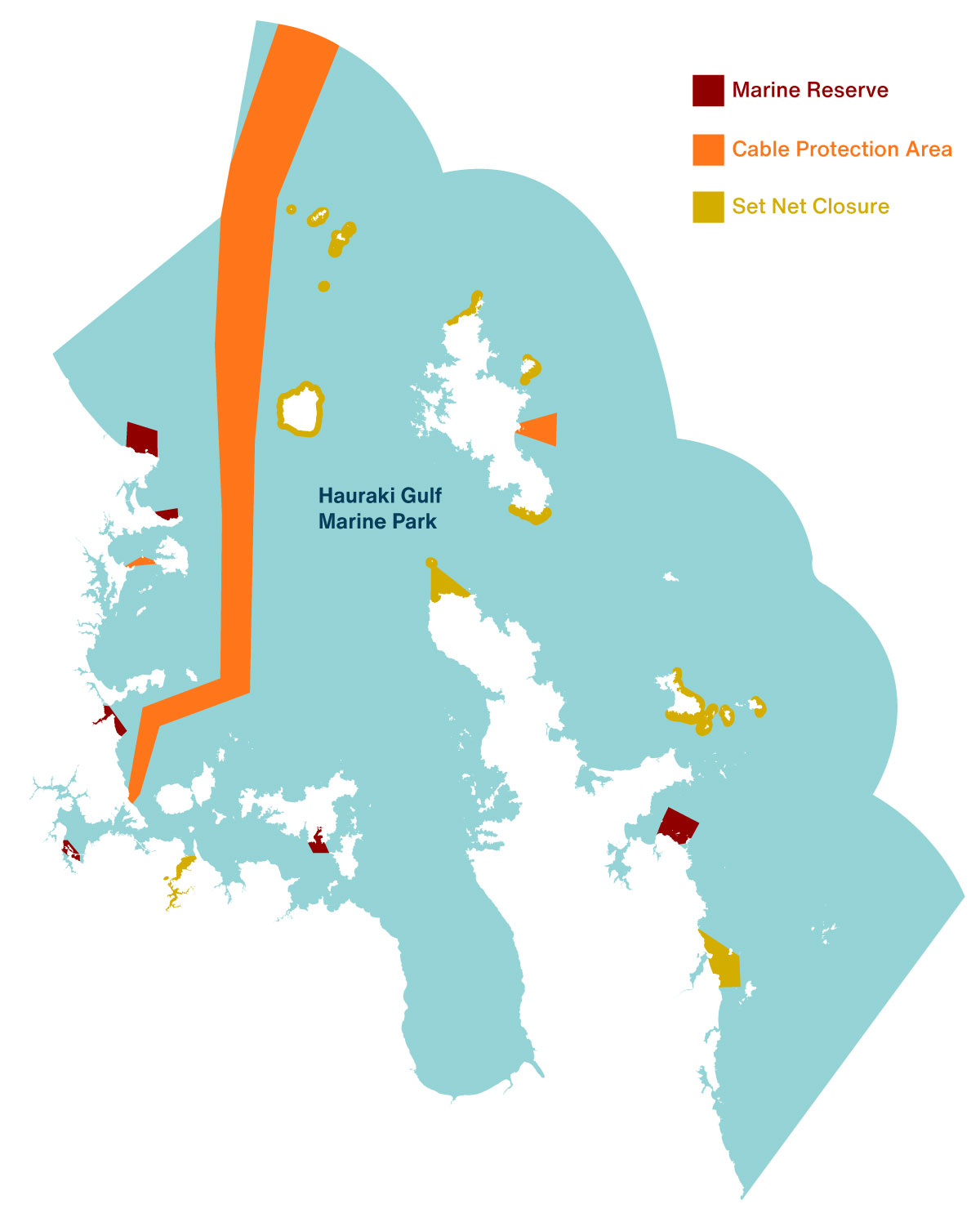
There are 79,899 ha of HPAs (5.96% of the Marine Park) and 5,833 ha (0.44 % of the Marine Park) in Marine Reserves (excluding the proposed Hākaimangō-Matiatia Marine Reserve). The State of the Gulf 2020 reported that Cable Protection Zones (CPZs) (which also prevent all forms of fishing) cover 4.9% of the Marine Park. However this Fisheries NZ report (page 5) says they CPZs cover ~6% and allow fishing from “small vessels that avoid bottom contact”.

== Below to be updated ==

  • 0.44 % of the Marine Park is closed to all forms of fishing.
  • 11.3% of the Gulf is protected from recreational fishers.
  • Recreational fishers are legally allowed to fish in 88.7% of the Marine Park.

The sand is alive

Feather duster tubeworm-Bream Bay-Photo by Shaun Lee

They often tell us that the seafloor is a wasteland. To the naked eye, or through the lens of those looking to profit from it, the vast stretches of sand off our coasts are described as “biological deserts.” But yesterday, diving in the waters of Bream Bay, I saw something else.

I was invited to join a group of marine scientists for a recreational survey in an area currently proposed for a sand mine. What we found wasn’t a desert—it was a nursery, a sanctuary, and a testament to the resilience of nature when we simply give it the space to breathe.

Signs of recovery

Our first dive took us to a spot where previous “dropcam” footage had hinted at life. As we descended, the reality exceeded our expectations. There were so tipa / scallops, everything from tiny juveniles to full-grown adults. Since this area was closed to scallop dredging on October 27, 2022, the ecosystem has begun to knit itself back together. In a world where we often hear only of environmental decline, seeing this rapid recovery was electric. As we surfaced, the lead marine biologist couldn’t hide his excitement: “Best dive ever!”

Tipa / scallop Bream Bay. Photo by Shaun Lee.
Tipa / scallops in a proposed sand mine in Bream Bay. Photo by Shaun Lee.

The moving seafloor

On our second dive, we followed a fish finder signal to a new spot. As I photographed the sand using my macro lens, I realised the sand was alive. The density of tubeworms was so high that the entire seafloor seemed to wriggle with life. These small creatures stabilise the sediment, filter feed, are attachment structures for juvenile scallops and food for fish.

A young sponge (lophon minor) growing in a tubeworm field in a proposed sand mine in Bream Bay. Photo by Shaun Lee.

Grab samples

Emptying the grab sample. Photo by Shaun Lee.

In between dives we used a grab sampler to look at the infauna, it was cool to see the little shellfish living in the sand but the highlight for me were the larger wiggling polychaete worms which I don’t often see.

An even better dive

At the end of the planned transect we discovered a low, flat outcrop of soft, peaty rock. It looked unassuming at first, but it was home to something I never expected to see in my lifetime.

Tucked into this small shelter was a huge pod of over 40 large packhorse rock lobsters. To find one or two of these creatures is rare, as they have been heavily overfished for decades. To see a pod of forty—mostly large males congregating together—was breathtaking. Sharing that space with them were juvenile and adult blue cod, goatfish, juvenile snapper and tiny larval fish.

Packhorse rock lobster in a proposed sand mine in Bream Bay. Photo by Shaun Lee.

This area is not only protected from seasonal scallop dredging since 27th of October 2022, but has been protected from bottom trawling for more than 40 years.

Memory in the water

Packhorse lobsters are known to navigate using the Earth’s magnetic field. Watching them as they traced their feelers over my face and shoulders I couldn’t help but wonder: how did they find this tiny, specific patch of safety in a vast ocean? Is it possible that the memory of these safe havens is passed down through generations?

If we allow sand mining to tear up this seafloor, we aren’t just removing “sand.” We are destroying navigational landmarks, generational homes, and a vital link in the marine food chain.

Blue cod in a proposed sand mine in Bream Bay. Photo by Shaun Lee.

Nothing there

There is a profound disconnect between what the scientists showed me and what industry describes. When pushing for extraction permits, proponents often downplay the biological value of the site. For instance, Callum McCallum, Managing Director of McCallum Bros Ltd, has previously justified mining by stating:

“It’s a very high-energy, mobile environment. To the naked eye, there is nothing there.”

After four surveys in this area, I can say with certainty: there is something there. Every time I go down, I find something more precious, more rare, and more worth saving.

We don’t need to “extract” value from Bream Bay. The seeds are already there, living and breathing beneath the waves. We just need to be quiet enough to let it recover.

Restoring Motukorea’s Forests with Feral Pigeons

Taupata / Coprosma repens regenerating on Motukorea

Motukorea / Browns Island is a visual icon of the Hauraki Gulf, but beneath its green slopes lies a history of heavy modification. Farmed for the better part of the last century, the island’s terrestrial habitats are now dominated by Kikuyu grass—a thick, aggressive mat that chokes out diversity and leaves little room for native flora to gain a foothold.

Recently, we began work at the southern tip of the island with a specific goal in mind: creating roosting and nesting habitat for endangered shorebirds. To do this, we sprayed back the Kikuyu grass, the first attempt with brush cutters was not successful.

As the grass died back, weeds quickly sprung up in the newly cleared earth. But while I was out there clearing these weeds, I looked closer at the ground and found something surprising.

Hidden gems in the weeds

Among the weeds were the unmistakable seedlings of native trees. I found two different types of Coprosma and a few young Karo plants. This sparked a bit of an ecological mystery. Where did they come from?

Aerial image of Motukorea in 1940. Source Geomaps / Auckland Council.

“There is no evidence of the island ever being forest-clad. It was cultivated for kumara and taro in the 1820s when visited by Samuel Marsden and RA.” – Esler, A. E. (1993). Plant Life of some Inner Hauraki Gulf Islands. Horticulture in New Zealand (Journal of The Royal New Zealand Institute of Horticulture), 4(2).

It is highly unlikely that these seeds survived more than 200 years in the soil bank. The most logical transport method is avian delivery—birds flying in and dropping seeds.

The unusual suspects

Usually, when we talk about forest regeneration in New Zealand, we look to our native pollinators and seed dispersers, like the Kererū or the Tūī.

However, on Motukorea, native fruit-eating birds are scarce. It is rare to spot a Tūī on the island and I can’t recall ever seeing a Kererū. So, who is doing the reseeding?

The island is, however, home to large populations of non-native birds like Feral Rock Pigeon, Starling and House Sparrows.

Feral rock pigeon on Motukorea

A novel restoration method

The theory is simple but fascinating. The clearing of the Kikuyu created a roosting and feeding area. As weeds fruited on the flats, the Pigeons and Starlings flocked in to feed. While they were there, they deposited seeds they had consumed elsewhere—perhaps from the few stands of mature native trees remaining on the island’s cliffs or even from the mainland.

It is a strange irony of conservation. We generally view feral pigeons and starlings as pests, yet in this highly modified landscape, they appear to be acting as the primary ecological engineers, bridging the gap that our absent native birds usually fill.

Thanks to our unexpected volunteers helping us replant the forest—one dropping at a time.

Pond water quality at Tahuna Torea Nature Reserve

I believe this is an inaugural report on pond water quality at Tahuna Torea Nature Reserve. The report summarises water quality monitoring before and after the recent koi carp removal project.

While too few fish were removed to see measurable changes, the work has provided useful baseline data on pond conditions. The findings also highlight the impacts of accumulated sediment and outline likely future pressures from sea level rise.

Net free areas of the Hauraki Gulf Marine Park

Kororā / Little penguin caught in net. Photo by Shaun Lee.

A friend asked me what areas of the Hauraki Gulf Marine Park are closed to all forms of fishing with nets. This is important if you are a dolphin, seabird, or fish that doesn’t want to be caught by these methods, which can take non-target species as well as the intended catch.

In the marine park, net fishing is done by purse seiners, bottom trawlers, Danish seiners, ring net fishers, commercial and recreational set net fishers, and recreational beach seine (drag net) fishers.

In the map below I have included the Marine Reserve Extensions in the proposed Hauraki Gulf Marine Protection Bill but excluded the Seafloor Protection Areas, which don’t restrict all net fishing, and the High Protection Areas (HPAs), which will allow customary fishing with nets. Two of the HPAs will also allow commercial ring-net fishing.

Although many areas with permanent Set Net Closures remain open to other forms of net fishing—like drag nets—it’s pretty rare except in the Tāmaki Estuary. The Cable Protection Area (CPA), however, is a true no-fishing zone: under the Submarine Cables and Pipelines Protection Act, all fishing and anchoring are prohibited. It’s pretty clear in the map that the CPA is doing nearly all of the real protection from nets.

The dairy–palm oil death spiral

Dr Mike Joy sent me this paper Flex commodities and intertwining world-ecologies: Indonesian palm waste as an environmental fix in the New Zealand dairy industry to read. It’s pretty technical, so I made a graphic summary to share.


It shows how depressing the dairy–palm oil death spiral really is: New Zealand’s droughts drive more palm kernel imports, which fuel deforestation in Indonesia, worsen climate change, and circle back to make our droughts even worse.

Forage fish are the fix we’re ignoring

A workup in FMA 1. Photo Shaun Lee.

The government’s plan to revitalise the Gulf includes creating new marine protected areas and phasing out bottom trawling in some zones. These are welcome moves, but they will take time—and they don’t go far enough.

The Gulf’s biggest problems—seafloor damage and sediment—are hard and slow to fix. We’ve dredged and trawled the biogenic habitats into collapse, then smothered what’s left with sediment from land. Even if we stopped all bottom-impact fishing and upstream erosion today, it could take decades for the seafloor to recover.

But rebuilding the forage fish layer—the small, plankton-eating species that transfer energy up the food chain—is faster, cheaper, and more within reach. The evidence is clear that this “wasp waist” of the ecosystem is under strain. Bryde’s whales have shifted away from fish toward krill. Kororā / little penguins are starving. Tākapu / Gannets and Tara / White-fronted terns are abandoning inner Gulf colonies. The State of Our Gulf reports point to these changes as signs of a food web in trouble.

Kokowhāwhā  / anchovies sheltering post ‘work-up’ in the Noises Islands November 2024. Photo Shaun Lee.

Yet despite all this, the latest advice from officials fails to move us meaningfully toward ecosystem-based management. The Hauraki Gulf Fisheries Plan includes a commitment to review the management of key forage species to “ensure that removals do not adversely affect the marine food chain.” But the current proposals do not deliver on that intent. Instead of aiming to rebuild abundance or account for the role of forage fish in the food web, the advice retains high catch limits for fish populations we know very little about. No stock assessments have been completed for kokowhāwhā / anchovy, kupae / sprat, takeke / garfish, aua / yellow-eyed mullet, or hautere / jack mackerel. We don’t know how many fish are out there, and we’re not using predator health or ecosystem indicators to guide decisions.

Instead, Fisheries New Zealand has proposed number-shuffling. The most recent proposals claim to reduce pressure by cutting catch limits, but the proposed limits are still higher than what’s actually being caught. That means there’s no real constraint on fishing effort. The door stays open for increases, even as the ecosystem shows stress.

Adding to the contradiction, tawatawa / blue mackerel—currently the single largest fishery by weight in the Hauraki Gulf—is proposed for an increase in catch. This species forms dense schools and plays a central role in mixed-species feeding events with dolphins and seabirds. At a time when ecosystem stress is evident, boosting the take of such an important forage species moves us in the wrong direction.

Juvenile tawatawa / blue mackerel in a marine reserve. Photo Shaun Lee.

Climate change is only making this worse. These species are vulnerable to rising sea temperatures and declining plankton. We can’t control the oceans response to climate change, but we can control fishing. Leaving more fish in the water builds resilience for the species that depend on them.

Fisheries New Zealand is not proposing ecosystem-based management. It’s pretending to act without changing outcomes. If we were serious about managing the Gulf as a living system, we’d listen to the dolphins, whales and seabirds.

The forage base is the fastest thing we can fix. But only if we’re willing to try.

My submission to Fisheries New Zealand on six forage fish populations in the Hauraki Gulf Marine Park.

Advice to Shane Jones on Trawl Corridors

On 13 May 2025, my request for the missing Cabinet paper and Regulatory Impact Statement on excluding bottom trawling and Danish seining from the Hauraki Gulf was declined, as the work had not been completed and the Minister was still considering his options. So on the 16th of May I asked for all briefings, advice, and communications provided to the Minister for Oceans and Fisheries about the exclusion of bottom trawling and Danish seining from the Hauraki Gulf Marine Park, from 1 November 2023 to the present.

I finally received the advice today (though some information has been withheld).

Some things that I learnt:


Observer bycatch data for the period 2012 to 2022 reported non target captures of benthic species on 34.4 percent of all observed tows, however, this is likely an underestimate as many corals and other vulnerable species fragment during contact with trawl gear and may be lost through the mesh of the net. In addition, not all tows are observed (for example, 5.1 percent of tows in the Gulf were observed in the 2021/22 fishing year).

97.2% of 8,909 submitters want a full ban on bottom impact fishing in the Gulf, plus 1.4% of submitters wanted Option 4 (the option that protects the most seafloor).

A 36,589 signature petition from the Hauraki Gulf Alliance was presented to Parliament in June 2023 in support of a ban on bottom trawling, scallop dredging and Danish seining in the Gulf. This petition rarely features in briefings to the minister on the topic.

Four iwi or iwi organisations submitted through the public submission process, one of which advocated for a complete ban of bottom trawling and Danish seining. The three other iwi or iwi organisations that submitted did not choose any of the proposed options as
they believe it undermines their rights guaranteed under the Treaty of Waitangi and Māori Fisheries Settlement rights. I should ask which iwi.

These are the companies and staff that are lobbying for the continuation of bottom impact fishing in the Hauraki Gulf Marine Park:

  • Mark Ngata – Moana New Zealand
  • Colin Williams – Sanford
  • Steve Tarrant – Moana New Zealand
  • Tiffany Bock – Seafood New Zealand
  • Vaughan Wilkinson – Sanford
  • Laws Lawson – Seafood New Zealand
  • Tom Searle – Lee Fish
  • Phil Clow – Whitianga and Coromandel Peninsula Commercial Fishermen’s Association

Seafood NZ tried to suggest an Option 5 for the trawl corridors which even more destructive than those proposed by FNZ. They tried to kill the SPAs and are also responsible for ring-net fishing debacle: “allow ring-net fishing in inner gulf (Kawau Bay, Motukawao, Rotoroa, Rangitoto and Motutapu) HPAs over winter months” FNZ staff did an okay job of defending the MPAs and telling the minister the proposals from Seafood NZ were bad ideas. (Government did not listen and there was a media storm on the issue).

Form submissions were ignored by staff when presenting % submissions to the minister. E.g. 85% of submitters support Option 4 or a complete ban, when the actual number is 98.6%.

Seafood NZ and Rock Lobster Industry Council lobbied the minister enough that officials considered allowing potting in a marine reserve!

Great to see push  back from staff that allowing these industry bodies to influence the process after consultation decisions had been made was/is not fair.

Interesting analysis of risks if trawl corridors abandoned:

  • 35% remnant biodiversity protected compared to 84-89%.
  • Would be widely criticised by many iwi, most stakeholders and the public
  • Councils may implement alternative protections through the RMA

Great to see FNZ consider that transitional support for affected fishers should be back on the table.


It’s a bit for me to reflect on but overall its just incredibly disappointing to see to see how the industry has been able to sway the Minister to delay a decision and stop a huge public process.

UPDATE 14 July 2025

In May I also asked for “Emails, memos, or meeting notes relevant to the decision-making process”. Apparently MPI could only find this one email.

UPDATE 31 July 2025

Request for mana whenua positions on limiting bottom impact fishing was ‘withheld‘. Good to see they consulted 23 mana whenua groups tho.

UPDATE 12 August 2025

Seafood New Zealand’s Hauraki Gulf options and protection bill amendment papers. Note:

  • Export values have been redacted.
  • Seafood NZ lobbied government to allow commercial fishing in 8 of the 12 HPAs. Ring net fishing also asked for in the Otata / Noises HPA, Motukawao HPA, Rotoroa and HPA. So far they have been successful in getting ring net fishing allowed in the Kawau HPA and Rangitoto / Motutapu HPA for the draft Protection Bill. They also pushed for Lobster potting in Te Hauturu-o-Toi / Little Barrier High Protection Area, Cape Colville High Protection Area and Mokohinau High Protection Area.
  • A note on the SPA prohibitions suggests the amendments were part of a longer discussion.

A tī kōuka reef

This is an experimental idea for restoring severely degraded seafloor ecosystems in the Hauraki Gulf Marine Park. It was inspired by reforestation efforts in China, where desertification is being tackled using tools like sandbag tubes  and straw fences.

The idea I tested was based on the concept of straw fences and how they stabilise loose substrates. Underwater, a similar structure might:

  • Stabilise the seafloor by reducing sediment movement
  • Improve water clarity by slowing currents and allowing sediment to settle
  • Provide structure for marine organisms to attach to or shelter in

To test this, I needed to see whether natural fibres could be planted in the seafloor and remain in place. I chose tī kōuka (cabbage tree) leaves because they are tough, fibrous, and slow to decompose on land.

tī kōuka (cabbage tree) leaves
20 tī kōuka (cabbage tree) leaves
The triangle marker on the Ōkahu Breakwater

I collected ten live leaves and ten dead ones, plus two extras to bind them into bundles. The leaves were 67–80 cm long. I kayaked to the triangle marker on the Ōkahu Breakwater (-36.84498185012416, 174.8125985293282) and selected a site 10 metres north of this point, where the substrate shifts from broken shell (common around the piles) to soft mud.

On a calm, high-tide day 25 March 2025, I dived to 5-6 metres and planted the leaves vertically into the mud using a 2 × 2 cm, 40 cm wooden stake, driving each leaf 15–20 cm into the sediment.

The live leaves were planted in a cluster with 5–10 cm spacing. The dead leaves were placed in a similar cluster 1 metre east of the live group.

10 live leaves, Note the substrate was a little firmer here than were I planted the dead leaves.
10 dead leaves, 1 meter east of the live leaves.

Now I wait for nature…