The enchanted gardens of North Eastern New Zealand

Photo Auckland Libraries Heritage Collections NZG-19071116-0009-03

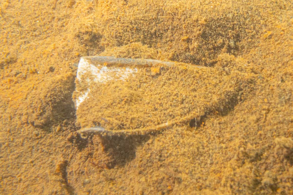
I was horrified by this photo I found in the Auckland Libraries Heritage Collection. It was taken 116 years ago in 1907. The caption reads ‘beautiful but profitless’ and describes a haul of corals and sponges undertaken by a research trawler. One large Black coral is remarkably intact, a tragic loss. The caption describes the scene “A haul as this—which in trawling parlance is “muck”—though useless is a glorious sight. This one in particular was gorgeous. The fish were a brilliant rose-pink, and all the hues of the rainbow were to be found in the strange dwarf trees, and other growths which came up in the net.”

The photo was from an article published in New Zealand Graphic which can be found in Papers Past, a second part to the article was published the following week.

The story is written about a single trip which started in Auckland on the 17th of October, the end is not mentioned in the article but based on the fisheries scientist’s report (from 1907 on PapersPast, there is also a 1901 report in the same National Library archive ) they went to the North Cape and back, making 23 trawls in 11 to 55 fathoms (20-100 meters). There are notes on all 23 trawls, the photo is likely from one of these:

Station 177: The net was shot again at 9.55 a.m., 6 miles N.W. £ W. of Channel Island, depth 25 fathoms, bottom mud and sand. As soundings indicated rough bottom, the net was only towed an hour and hauled up in 27 fathoms, bottom coral and shell. The result of this haul, poor both as regards the quantity and variety of fish.

Station 178: From last station steamed 5 miles S. x E., and shot the net at 12noon, 4miles S.S.E. from Little Barrier, depth 28 fathoms, bottom mud and sand. Hauled up 4J miles W. \S. of the Little Barrier in 28 fathoms, bottom coral and shell. This was also a short haul, and the results were as poor as the previous one.

Station 183: Left Russell at 6 a.m. for Great Exhibition Bay, near the North Cape. Arrived there and shot the net at 3 p.m. in 32 fathoms, the soundings made showing sand and shell; but the net had only been towed ten minutes when it fouled, and. when hauled up it was found that the foot-rope was cut through, showing plainly that it had come in contact with rocky bottom.

Station 191: After hauling up from station 190 several soundings were taken, and showed a risky bottom, so we steamed south 17 miles, and shot the net at 4.30 p.m. off Takau Bay in 35 fathoms, bottom fine sand. Towed S.E. 2 miles, and hauled up from the same depth and character of bottom as we shot in. This was a very poor haul as regards fish-taking : the net came up with large quantities of marine vegetation. After hauling up we steamed into Russell, and anchored for the night.

They lost a £lOO net on “foul ground” and they were constantly mending nets. The author describes the seafloor based on the bycatch “places must be like a fairy grove, or one of those enchanted gardens in the Arabian Nights”. He goes on to describe a particular haul from the Bay of Islands in detail:

“There were several dwarf trees about three or four feet high, which realised one’s idea of the sort of thing that grew in the garden of the Princess Bulbul. They had evidently been torn from the solid rock. The branches were covered with feathery leaves of a most delicate form, coloured cream-brown, and attached to them were all manner of things just like a Christmas-tree. From a short distance off, it was difficult to say that it was not hung with all manner of vivid-hued fruits—bananas, grapes, tomatoes, and what not—anu round the branches at intervals were twined starfish in knots resembling what sailors call “Turk’s Heads.” They were not spiked like ordinary star-fish, but smooth and bright as a Japanese lacquered box. Some were cream with maroon stripes, others a rich golden yellow, others crimson, and on no two was the marking the same. From one branch depended a cluster of things half prawn, half sea-horse, and from different points swung shark’s eggs—a semi-transparent lyre-shaped bag of the same colour and quality as celluloid (from which it was difficult to distinguish it), some four inches in attached to the shrub by cartilaginous tendrils, whose spirals seemed intended by wonderful Mother Nature to catch in such growths and find a safe hatching place. One branch minus leaves, if one could so term the feathery growth, looked exactly like a frond of coral, the colour a rich crimson-lake, with the tips of the countless excrescences lighter in tint. On a closer examination the branch was found to be sheathed with a gelatinous substance, quite soft to the touch, which soon dried and lost its exquisite colour.

Some of the shells were very strange and interesting, particularly one that seemed to be very plentiful. It was an ordinary-looking spiral shell as big as a man’s hand, but round the base was ranged a number of smaller shells, forming a sort of base which would apparently keep the shell off the ground, like a house on piles. They were stuck on with some kind of cement, and in other specimens small stones or pebbles were used in a similar way.

Sponges, and fungoid growths of many colours and fantastic shapes—umbrellas, hats, bowls, etc.—were common, and some of them weighed half a hundredweight and more. Star fish, squids, molluscae, medusae, seaweed and yards of gelatinous transparent stuff as thick as leather and marked with red spots were brought up at nearly every haul. They would no doubt be greatly prised by the naturalist, but are shovelled over without the slightest compunction by the business-like fisherman.”

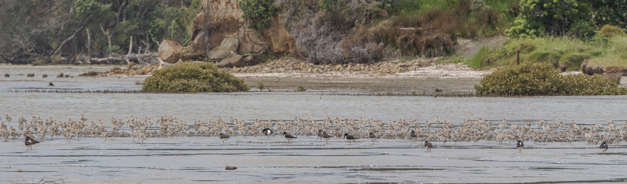
By 1907 there were many trawlers operating around the country, many purchased with government subsidies. There had been much public outcry about the method and one area in the Gulf protected (temporarily) but only after it had been trawled. In 2023 commercial bottom trawlers and Danish seiners will repeatedly deploy their gear thousands of times within the Hauraki Gulf Marine Park alone.

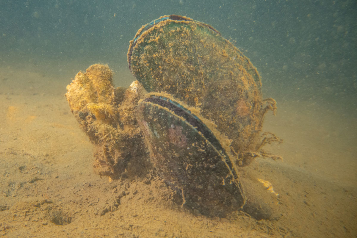
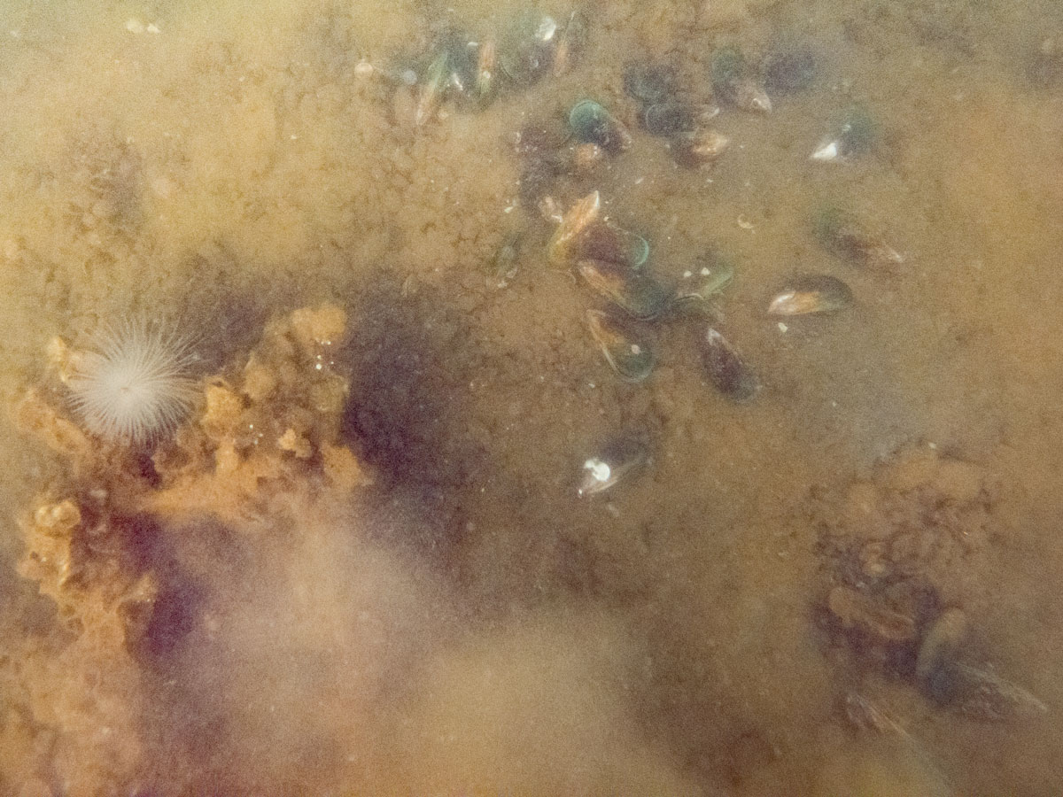
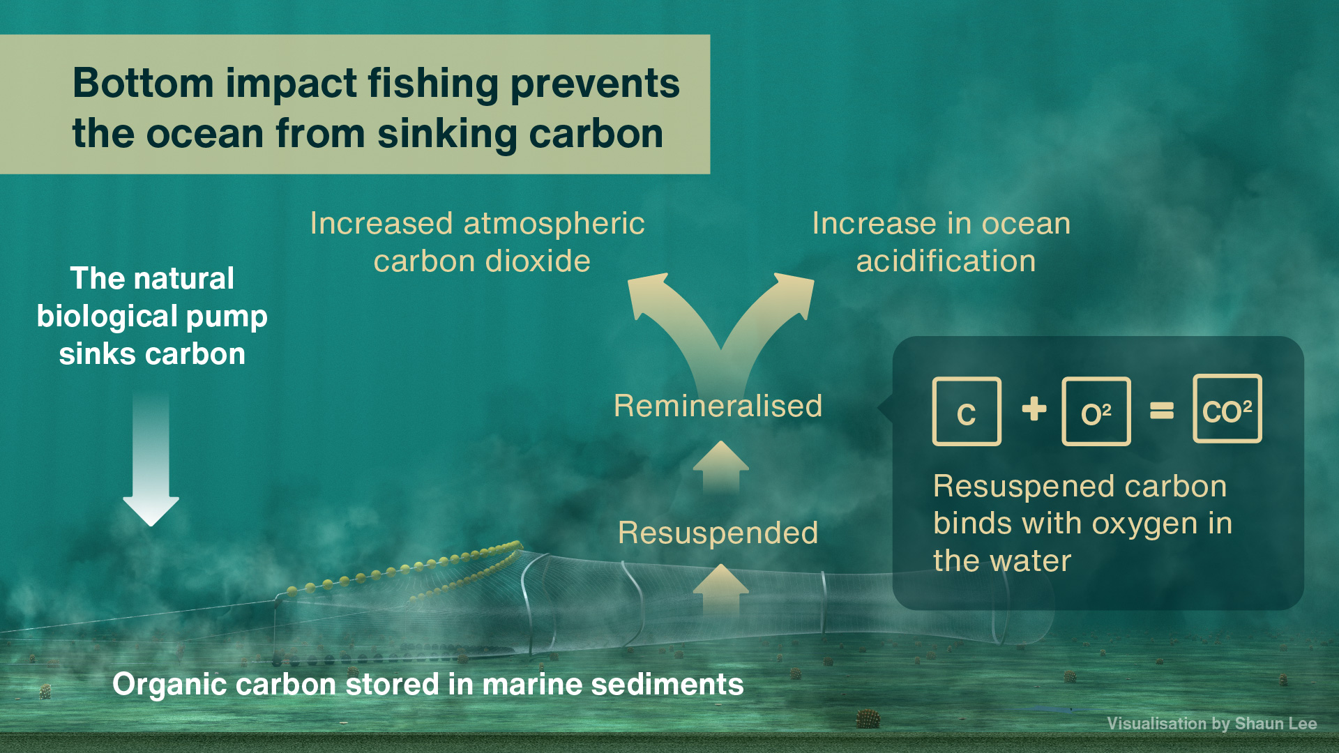
The image is a stark reminder of what’s been directly lost to mobile bottom impact fishing. The industry like to say they only trawl on ‘sand or mud’ but we know that our mud and sand once supported more complex habitats. Examples of biogenic habitats that associate with soft sediments include horse mussel beds, scallop beds, dog cockle beds, green-lipped mussel beds, seagrass, sponge gardens, tubeworm mounds and rhodolith beds. Our poorly protected corals and other epibenthic fauna like sea squirts attach to hard structures created by these habitats, enriching and expanding these ‘enchanted gardens’. All of these habitats are easily destroyed by mobile bottom impact fishing.

To this day NIWA carry on this tradition of ‘scientific’ bottom trawling for the government, even in areas protected from bottom trawling. Some tows are stoped due to ‘foul ground’. When will we stop all mobile bottom impact fishing and begin to restore our ‘enchanted gardens’?

My experience in designing ‘trawl corridors’

Unlike the Sea Change 2017 marine spatial plan that sought to phase out bottom impact fishing from the Hauraki Gulf Marine Park the governments response (Revitalising the Gulf 2021) was to create ‘trawl corridors’. Bottom trawlers do not have a public license to keep smashing the seafloor, a 2021 Horizon Research poll had 84% support for a banning the practice. I love the seafloor and volunteer for an organisation that restores damage done to it by bottom impact fishing. I’m completely opposed to trawling as a fishing method but I put my hand up to help limit its impact in the Gulf using a science based process by joining the Hauraki Gulf – Benthic Spatial Planning Advisory Group (HG-BSPAG).

This was my first experience in a collaborative decision making process run by the Government with industry representatives. I represented an environmental Non-Government Organisation (eNGO), there were three eNGO participants, everyone else was either from NIWA, central & local govt or the fishing industry. The process was chaired and controlled by Fisheries NZ. The other two eNGO participants were awesome and I learnt a lot from them.

I particularly liked the data first approach to marine spatial planning, Zonation is a great tool and I liked the way it starts by removing the human impacts then making an economic case for re-introducing them. Unfortunately some data that would have been useful was not quite complete.

Fisheries NZ controlled the outputs by defining what is in scope. Here is a list of requests that were disregarded:

  1. Ground truthing the modelling work (out of scope).
  2. Modelling the distribution of Unwanted Organisms (UOs) . We know from NIWA surveys that trawl nets catch UOs in the HGMP, transporting UOs is an offence under Section 52 of the Biosecurity Act 1993. By excluding UO’s from the study FNZ failed to protect native benthic habitats from UO’s which can be spread by bottom impact fishing (see appendix for more details).
  3. Infauna (animals that live in the sediments) that are sensitive to bottom impact fishing were excluded from the modelling due to technicalities.
  4. Mobile species that contribute biogenic habitat like tipa / scallops (see appendix) and burrowing animals like ghost shrimp and crabs were excluded because they were mobile which did not suit their definition of biogenic habitat. This is ridiculous as the smallest grid size is 250m and previously mentioned adult animals are unlikely to move more than 10m.
  5. Important habitats for fish (like spawning and nursery areas) were not considered (out of scope).
  6. The indirect effects of bottom impact fishing. Sediment plumes from bottom impact fishing choke and kill filter feeding animals and smother photosynthesising plants. These effects were not included but have been discussed at the end of the report.
  7. Climate change impacts (e.g. CO2 released from resuspending sediments and heart urchins moving deeper as water warms) also not included but have been discussed at the end of the report.
  8. Modelling the economic benefits of excluding bottom impact fishing to other fisheries that don’t impact the seafloor, this could have dramatically altered the findings (out of scope).
  9. Monitoring changes in the money made in an area over time during the transition from one fishing method to another, I think it’s critical this is done with any changes to bottom impact fishing.
  10. Using the regulations, not existing fishing effort, as the starting point for limiting Danish seining (see appendix on Danish seining regulations). Despite multiple requests FNZ would not even put the existing regulations on the maps.
  11. Protecting the deeper areas of the HGMP (see appendix).

We did not discuss substrate. Is it better to trawl on sand which emits a smaller plume but may transition to mud with intensified disturbance, or mud which has a larger sediment plume? We know repeated bottom impact fishing alters the chemistry of the seafloor.

The narrow scope of the project was frustrating because there is an aspiration for Ecosystem Based Management of the Hauraki Gulf Marine Park. Once all the environmental effects of bottom trawling and Danish seining are considered, the fishing methods should be banned everywhere.

I have some sympathy for fisheries managers, they have specific deliverables and get pushed around by industry. I did think their approach was often callous, in the face of uncertainty they often chose the status quo rather than taking a more precautionary approach. One member of the Hauraki Gulf Fisheries Management Plan Working Group HG-FMPWG that will finish the corridor design work has publicly criticised the process.

There were no opportunities for feedback on the corridors the scenarios produced. Final trawl corridor design will be Fisheries NZ’s responsibility and will get input from the HG-FMPWG. Other than the above I have no criticisms of the process, it just needs bigger budgets and managers who care more about te taio. I learnt a lot and am happy to volunteer my time again to use scientific modelling in a spatial planning process to protect the environment.

One difficulty I had was proposing trawl corridors. I decided not to volunteer a low impact scenario because the process had already generated a near zero impact scenario which I thought was reasonable (Similar to Figure 14C in the published report – 90% of recovery potential habitat and current trawl footprint & current/proposed protected areas and 100% of current distribution of biogenic habitat (minimising impacts on trawl fishery.) This meant I was left very unhappy with the scale of the proposed scenarios. It was obvious that the scenarios would need work before Fisheries NZ could designate corridors, however I may end up regretting that decision.

I hope Fisheries NZ will monitor recovery (which may take centuries) the data gained could help ground truth this model and develop more robust models in future.

You can read the published report on the design process here: Exploring the use of spatial decision support tools to identify trawl corridors in the Hauraki Gulf Marine Park

Advice for the Hauraki Gulf Fisheries Management Plan Working Group

The outputs of the process will be used by the Hauraki Gulf Fisheries Management Plan Working Group to design bottom trawling corridors in the marine park. Here are some key points they should be aware of:

  • Because the process is not ground truthed and does not account for secondary impacts, important habitats for fish or climate change impacts a precautionary approach should be taken. (I suggested massive buffers but they were deemed out of scope).
  • Danish seining impacts have not been included in the model. This skews the impacts, recovery in areas where this fishing method is practiced has been understated.
  • The corridors should be much deeper (further from the coast) to avoid the illegal transport of Unwanted Organisms.
  • Consider the existing Danish regulations as the starting point, not the area where the fishing method is currently practiced.
  • Protect the deeper areas of the Gulf because they are included in the Hauraki Gulf Marine Park (see appendix).
  • Include monitoring (fisheries method transition) in any recommendations.
  • Take special note of the sediment resuspension impacts detailed on page 68 of the report which were excluded from the study.

Appendix

Avoiding tipa / scallop beds

Running heavy trawl gear over tipa / scallop beds is incredibly damaging and foolish behaviour. It not only damages the tipa including juveniles, but also the settlement substrates the tipa use as part of their lifecycle. The Review of Sustainability Measures for New Zealand scallops (SCA 1 & SCA CS) for 2022/23. 3.1.18 states that:

“Within the Hauraki Gulf Marine Park, overlap between trawl activity and scallop beds will be considered as part of the proposal to establish defined ‘trawl corridors’ that will limit the areas where bottom trawling can continue to operate. With the introduction of electronic reporting and Global Position Reporting (GPR) on commercial fishing vessels, Fisheries New Zealand has the ability, through fine scale data, to monitor any notable overlap between fisheries and methods.”

It was frustrating that even though tipa are the most surveyed biogenic habitat in the Gulf the fisheries scientists decided that instead of identifying them they would just model their associated habitats. In the paper they literally say they ‘hope’ that this would mean the beds would be avoided rather than just mapping them out. Only the small beds that remained open at the time of the study (the fishery has since collapsed with bottom impact fishing implicated as a key stressor) were removed from the study area.

The rationale for the exclusion of tipa was that they are very mobile. This is ridiculous given the grid size of the study is 250m. Adult tipa and burrowing animals are unlikely to move more than 10m in their lifetime. For adult tipa mobility see Morrison, M. A. (1999). Population dynamics of the scallop Pecten novaezelandiae in the Hauraki Gulf (Doctoral dissertation, ResearchSpace@ Auckland).

Danish seining regulations

The restrictions prescribed in fisheries regulations for Danish seining define a different area than what is currently applied by Fisheries NZ. The State of our Gulf 2020 quotes Fisheries  NZ as ‘committed to reviewing this discrepancy as part of management actions put forward in a fisheries plan for the Hauraki Gulf’. The discrepancy is not recorded in the final report.

Protecting the deeper areas of the HGMP

The deeper areas of the HGMP were excluded from the final scenarios. I asked that they be protected because:

  1. The edges of continental shelves are biodiversity hots spots. Predicted diversity along the depth incline is one of the reasons for excluding the area from the model.
  2. This process was designed to protect biodiversity.
  3. This is the only deep water area in a marine park in New Zealand.

Unwanted organisms discussion document

Here is the discussion document on an unwanted organism (Mediteranean fanworm) I prepared for the working group, similar logic could have been applied to other species including the two recently introduced Caulerpa species.

Omissions

The report details protection measures proposed by Sea Change 2017 but omits the most important benthic protection measure, “the phase out of all bottom trawling, Danish seining and scallop dredging from the Hauraki Gulf, with all such methods excluded by 2025” It’s a strange omission that reads like an attempt to exclude the measure from the history books.

Northern New Zealand dotterel productivity rates

Northern New Zealand dotterel are classified as a Conservation Dependent species, this means that without human help they will go extinct (usually because of predation from introduced predators like rats & cats). So how do you know if your local dotterel are going extinct or not?

Well first you need to work out their productivity rate. Productivity is measured by the average number of chicks fledged per breeding pair (per season). Fledglings divided by pairs. So if you had two pairs and they fledged one chick you can say the site averaged half a fledgling (0.5) per pair.

1 fledgling / 2 pairs = 0.5 productivity

0 fledgling / 2 pairs = 0 productivity

1 fledgling / 3 pairs = 0.33 productivity

Management is considered effective if productivity values are greater than 0.5 for three consecutive years or longer (Dowding & Davis, 2007).

I help manage dotterel at three sites, I can not claim effective management and any of them. This means that over time these sites are a population sink. It’s important to track and share this metric to help conserve the species.

Update April 2025:

New research published by (Dowding & Chamberlin 2025) has found that Variable Oystercatcher have higher survival rates than Northern New Zealand dotterel, so they require a lower productivity rate—0.22 chicks fledged per pair per year or more—for the population to be sustainable and management to be considered effective.

Protected species bycatch in the wider Hauraki Gulf region 2019-2020

This OIA request for photos of bycatch by observers on commercial fishing boats was sent August 2022 and answered 24 February 2023 due to technical issues.

Please supply the following information under the Official Information Act (OIA):

1. All photos of the two black petrel caught by snapper longline fisheries between 2019-20 in this map. There are no photos of these captures as the birds were released alive. The priority is to release live birds as quickly as is possible and there may not have been time to take photos. This part of your request is therefore declined pursuant to section 18(e) of the OIA.

2. All photos of the seven flesh-footed shearwater caught by snapper longline fisheries between 2019-20 in this map.

3. All photos of the flesh-footed shearwater caught by minor bottom longline fisheries between 2019-20 in this map.

Only one individual shearwater was captured and only one photo was taken of the capture.

4. All photos of the white pointer shark caught by snapper longline fisheries between 2019-20 in this map.

5. All photos of the leatherback turtle caught by bigeye longline fisheries between 2019-20 in this map.

The leatherback turtle was released alive

6. All photos of the green turtle caught by southern bluefin longline fisheries between 2019-20 in this map.

Please report set nets in the Tāmaki Estuary

I made this sign to help the Tāmaki Estuary Protection Society enforce the set net ban. I am uploading it here so that the map in particular is easily found on the internet.

Set nets are banned in the Tāmaki Estuary. Set nets indiscriminately catch non- target fish species; birds and mammals. There has been a recent increase in illegal set netting in the Tāmaki Estuary, please help protect our fisheries and other wildlife.

If you see a set net within the banned area:

  • Please urgently contact 0800 4 POACHER (0800 47 6224)
  • Please report the set net location details and any vehicle license plate. Photos and details can be emailed to poacher@mpi.govt.nz

Your kaitiakitanga will be appreciated by generations to come, kia kaha!

Here is the link to a PDF of the sign.

Dredged to death

Fridays closure of the last two tipa / scallop beds in Aotearoa / New zealand will mark an historic moment for our fisheries. It signals the collapse of more than a fishery but an entire ecosystem. 

The last commercial mussel was dredged out of the Hauraki Gulf in 1966, after 56 years there are no signs of recovery. We don’t yet know what the fate will be for tipa. The fishery at the top of the South Island has been closed since 2017. If the tipa beds do not recover it will be the best evidence of ecocide in Aotearoa / New Zealand this century.

We need to change our ways. Both recreational and commercial dredging must be banned as per the Hauraki Gulf 2017 marine spatial plan that the government has still not acted on. These fishing methods damage the habitat that the animals grow in.

The result is:

  • Dead and damaged non target species and juvenile tipa
  • Lost biodiversity and water clearing animals
  • Lost habitats for fish especially juvenile fish
  • Long term changes to seafloor chemistry

The same impacts are created by other bottom impact fishing methods like bottom trawling and Danish seining which were also to be banned in the marine spatial plan. Short term fisheries closures are not good enough, we need a total ban on these methods.

Central government management actions to date have been irresponsible. Auckland Council did not take action when it was asked.

If the tipa beds do not recover naturally who will pay to restore them?

Missing data from Revitalising the Gulf consultation

During the October 2022 consultation round on the marine protection proposals for Revitalising the Gulf I asked Govt a few questions. Some of them were quickly answered but a few others were converted into an Official Information Act request. From that I was able to draft this table showing changes in spatial use of the Gulf proposed by the plan, this is important given it’s a Marine Spatial Plan.

A new idea proposed in the plan (based on Sea Change 2017) was that customary fishing could take place withing the High Protection Areas (HPAs). There was no advice provided on how much customary take might happen in the HPAs, this is important as it impacts level of protection provided by the policy. I asked:

“Are you able to supply how much customary fishing (including commercial customary) was undertaken in the proposed HPAs in previous years? This would aid conversations with people concerned about future levels of customary take. I understand catch records may not have precise associated location data, an estimate is fine.”

I received a painfully detailed response. Here is the map and raw data, I spent a few hours with it trying to answer my question. In my opinion the data is unusable. For nearly every population there is a unspecified number given for what was taken. For example:

In 2018 & 219 there were 1,064 kgs of snapper taken as customary catch but there is an additional number of 438 with no unit specified.

If we just stick to the kgs and compare data from 2018 & 2019 to contextualise it with fishing data from the last State of the Environment Report there was about one tonne of tāmure / snapper taken as customary catch. Total commercial take of tāmure in the Gulf was about 1,600 tonnes and recreational take was 2,000 tonnes. So customary catch might only be 0.03% of the total catch and insignificant from a population management perspective. However there is another number of 438 given with unit unspecified. If the number is tonnes then customary catch is 12% of the current catch, spatial changes in this effort would be significant from a population management perspective. The 2022 data is also dominated by unspecified numbers.

I have not been able to use the data to answer my question, the reporting system for recreational and customary take needs an over haul. Its frustrating as there is a great app that has been developed for reporting customary take (IKANET) which must be unused.

How to manage dogs in banned areas

Note this was written from the perspective on an average sized white male in his 40’s, you may need different tactics. The number one rule here is to never put yourself in danger.

Scenario 1. The dog is off-lead and there are threatened breeding birds in the area.

Chase after the dog. This shows the owners that something is really wrong, especially if you don’t look like the kind of person who likes to run. In my experience the dog usually returns to the owner, you can then have an (out of breath) conversation about why it’s important not to have dogs in the area.

Scenario 2. The dog is on a lead, there are no threatened breeding birds in the area.

Introduce yourself to the dog owners like you are an old friend. Be warm and in their face. This shows you are not somebody to be ignored but also not threatening. I like to shake their hand and tell them what I do here, my name, I also ask for theirs. Kindy explain to them that they must have missed the no dogs sign and send them back the way they came. It’s a good idea to walk with them as this shows how serious you are. Asking them about their dog(s) helps you come across as relatable, it’s also useful to find out if they are a local.

Scenario 3. Dealing with repeat offenders.

I have actually never had this problem but I received this advice from Auckland Council after having an argument with a local who was determined he was allowed to walk his dog somewhere where he was not.

1. Record the offenders details.

  • Ideally you already have their name from Scenario 2, if not ask for it again in a friendly way and apologies for forgetting.
  • Get a description of the dog (its breed, colour, sex, size etc and a description of the collar).
  • If the dog is not with its owner and it is safe to do so you might be able to get its tag details, for this you want the tag number and expiry date.
  • You might be able to get a photo of the owner or dog.
  • You might also be able to follow them to their car or house to record a license plate or address – but never put yourself in danger.

2. Report the details to Auckland Council (09) 301 0101 with the time, date and location. You will also need to report your contact details.

If Council officers are able to locate the owner an infringement may be issued. Keep a record of the incident for yourself. If there are regular incidents you can ask Council to do monitoring. In this case someone from the animal management team will visit the reserve. My understanding is that they can issue infringement notices on the spot.