This summer many people asked me about a front page article on the New Zealand Herald about a large black marlin that was killed off the coast of Northland. They wanted to know what I thought about it because they knew I would disapprove. The article did not include other views on the anglers “monumental effort” which took 10 hours. People posted negative reactions to the article on Facebook calling it animal torture but there was a shortage of facts about conservation and moral concerns.
Is marlin fishing sustainable?
In Aotearoa New Zealand the fishery of marlin is 100% recreational since 1988. Billfish caught overseas should not be bought to eat because bycatch from this fishery is going extinct (whales & dolphins, sharks, seabirds and turtles). Our commercial catch of billfish is not targeted due to a Memorandum of Understanding Between Commercial & Recreational Fishing Interests October 1996. However there is a targeted commercial Swordfish fishery. Commercial landings have fallen dramatically over the last 10 years indicating a change in fish population, fishing methods or reporting, the former is most likely and concerning *. The 126 tonnes of landed in the most recent year represents more than 1,000 fish, more than the number of animals reported in the recreational tag and release programme. Other billfish like marlin are released whether the animal is alive or dead upon capture. Cameras on all commercial surface longline fishing boats would tell us how many of these animals are being released (alive or dead).

The population trend and conservation status of each species is assessed by the International Union for the Conservation of Nature (IUCN). This is how they categorise the threat of extinction for all species on our planet.

Here is how our billfish populations are doing in 2023 with recent catch data from the tagging program.


Most of the recreationally caught animals are striped marlin, although they are categorised as Least Concern, the population in the Southwest Pacific is overfished with an estimated decline of 25% between 2001 to 2016.
Aotearoa New Zealand participates in the Western and Central Pacific Fisheries Commission to manage billfish populations. This 26 member commission is slowly making progress towards sustaining the world’s biggest tuna fishery, but failing to manage bycatch including billfish. The commission meets just once a year to make decisions via consensus. Aotearoa New Zealand is responsible for a very small percentage of the fishery. We have the moral high ground and are well positioned to argue for changes to stop these species from going extinct.
While commercial billfish bycatch in Aotearoa New Zealand is unknown, recreational fishers both target and land billfish. Because our fisheries are recreational, reporting on how many billfish are caught is voluntary. The latest report on the tagging programme notes an increase in the number of boats and a probable increase in unreported catch. This needs to change and more information would help us with our questions about the conservation status of these species. Climate change will push billfish populations towards the poles, increasing catches in Aotearoa New Zealand and masking our ability to detect population decline here.
The sports fishing industry awards and celebrates the capture of the largest fish. Large old fish produce more eggs and sperm than younger fish. Female billfish are larger than males. This means the most productive members of the population are landed for records, trophies and prizes. A large blue marlin at a weigh-in station does not represent a gain of 500kgs of freezer meat, but a loss of millions of eggs which could have helped rebuild the population. The situation is just as important for our striped marlin which have lost 94% of their spawning biomass since 1960’s.

As our culture evolves fishing is becoming less about machismo and more about connecting with the environment. Recreational fishing industry leaders could do more to discourage fishing techniques that target species that are going extinct. They also need to find ways to land less big fish. It won’t be easy for them, change may take a generation. Is catch and release the solution?
Is catch and release helping conserve billfish in Aotearoa New Zealand?
About 800 of our billfish are caught, tagged and released every year. The tagging programme is voluntary for recreational and commercial fishers. On average only three of these are recaptured per year. The other 797 plastic tags (which cost $5 each) end up in the ocean. Some tags fall out, some sink to the bottom of the ocean with the exhausted fish.
Many billfish are released, all of them injured. The fish are vulnerable to shock, disease and predation.

Overseas studies have found survival is not great with one in seven released fish dying. Fishers gamble with the lives of these animals every time they put a hook in the water. The ‘catch and release’ practice makes a significant contribution to the sustainability of our share of the fishery – if its stopping those fish from being landed and killed. However it’s unquestionable that the fish would be better off without being caught at all.
The small number of recaptures have shown where our fish travel, but much more information could be gained by using satellite tags. Genetic sampling techniques are better conservation tools and have existed for more than five years.
With so little conservation value in the tagging programme, is it worth it?
Is catch and release humane?
Sportfishing is practiced by humans who primarily hunt for fun rather than food. It’s a blood sport where wild animals are stressed and wounded for the pleasure of the hunter. In 2003 scientists found that fish have the biology to perceive pain and demonstrate behaviours associated with pain. The science was controversial for more than a decade, but now seems settled and researchers have now moved on to what kind of painkillers to give fish in laboratory experiments.
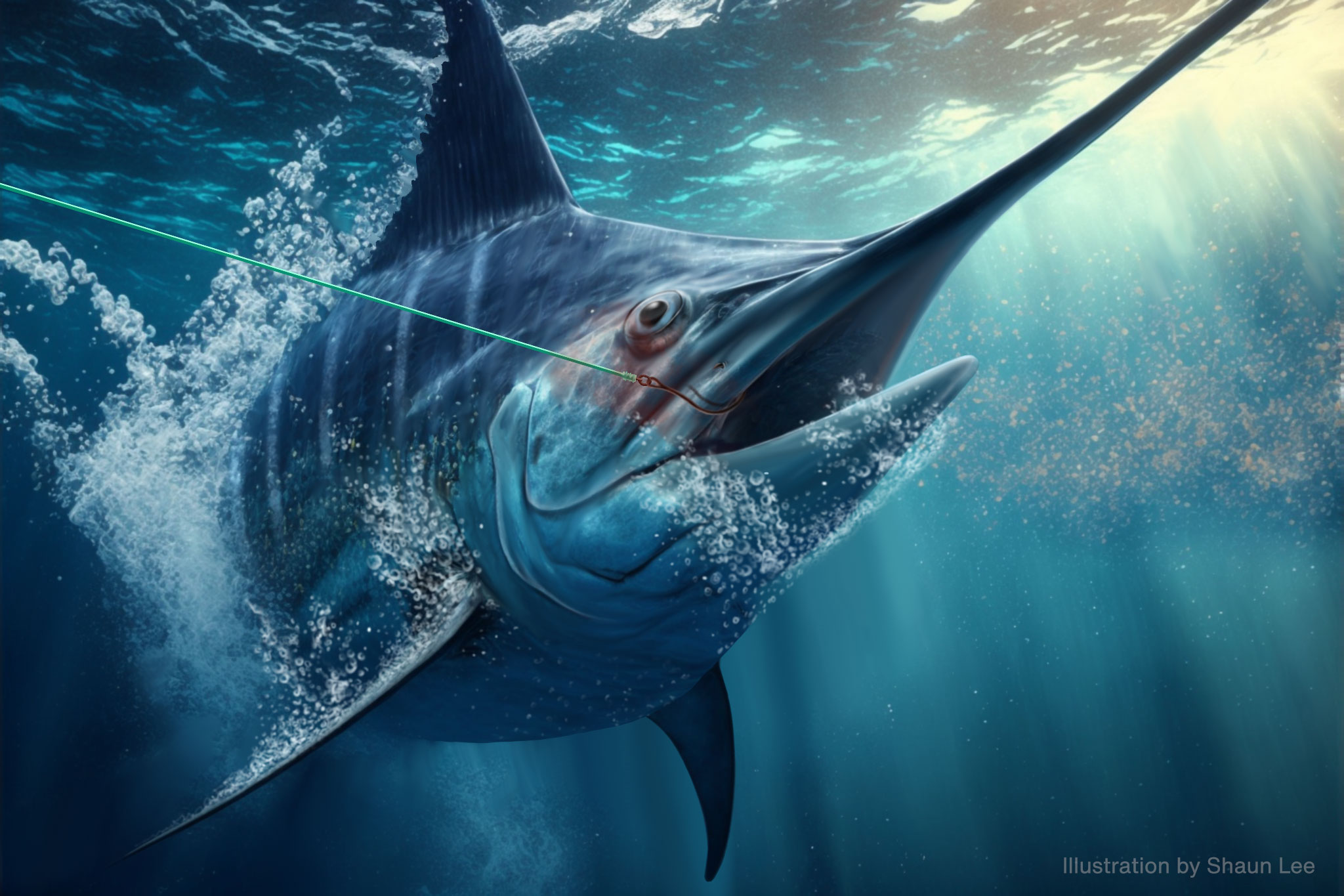
Billfish respond to a hook in the mouth, throat or guts by trying to move away from the source of the pain. Fishers call this the ‘fight’. The amount of fight a fish will put up to reduce its suffering is extended by international game fishing rules. These rules are endorsed with additions from Legasea / The New Zealand Sports Fishing Council. They encourage fishers to try and land game fish on lighter line classes. This is thought to give fish a “sporting chance” as heavier fish can more easily break lighter lines. This makes the fights (which the fisher instigates for their own enjoyment) longer, it’s not uncommon for fights to last hours. This is done at the expense of the fish. Longer fights prolong the suffering of billfish and increase the chances of post release mortality due to physiological stress.
The New Zealand Society for the Prevention of Cruelty to Animals (SPCA) opposes big game fishing for sport due to the prolonged pain, injury and distress on the fish involved. SPCA advocates for a ban on the use of “light tackle” to catch big game fish.
The New Zealand Animal Welfare Act 1999 recognises fish as sentient animals. The activity recklessly ill-treats animals (an offence under section 28 A) it also contravenes other sections of the act (30A1-3). There is a NAWAC guideline on how to deal with practices which are inconsistent with the spirit of the Animal Welfare Act. The guideline asks ‘Is the suffering necessary’? It is not necessary and undeniably inhumane.
There is enough conservation and moral evidence to take the precautionary approach and stop the sport today, but I think it should be phased out, like big game hunting overseas.

What should we do?
Aotearoa New Zealand should show leadership by pushing for global population estimates using genetic tools. We need to do a better job of arguing for changes to international fisheries methods and quota. We can also show more leadership by mandating the reporting of caught billfish (both landed and released, commercial and recreational) and developing a Code of Welfare for sports fishing which will identify standards to prevent pain and distress.
* UPDATED APRIL 2024. Phil Clow (president of the Whitianga and Coromandel Peninsula Commercial Fisherman’s Association) pointed out that the drop in commercial swordfish catch is due to fishers targeting tuna instead. I looked into it and it does look like that accounts for 50% of the drop. Annotated graph below.